Math Is Fun Forum
You are not logged in.
- Topics: Active | Unanswered
#776 2020-09-02 00:58:43
- Jai Ganesh
- Administrator

- Registered: 2005-06-28
- Posts: 51,576
Re: Miscellany
654) Iguana
Iguana, any of eight genera and roughly 30 species of the larger members of the lizard family Iguanidae. The name iguana usually refers only to the members of the subfamily Iguaninae. The best-known species is the common, or green, iguana (Iguana iguana), which occurs from Mexico southward to Brazil. Males of this species reach a maximum length of over 2 metres (6.6 feet) and 6 kg (13.2 pounds). It is often seen basking in the sun on the branches of trees overhanging water, into which it will plunge if disturbed. The common iguana is green with dark bands that form rings on the tail; females are grayish green and about half the weight of males. Iguanas also possess atrophied venom glands that produce a weak harmless venom.
Food of the common iguana consists largely of leaves, buds, flowers, and fruits of fig trees (genus Ficus), although many other trees are also fed upon. Whereas this lizard has a well-developed digestive system housing bacteria that ferment plant material, it also eats invertebrates when young and has been known to eat small birds and mammals.
During the rainy season, males become territorial, and mating pairs are established. At the end of the rainy season, eggs are fertilized and then laid in clutches of 30 or 50 in the ground during the early dry season. After 70–105 days, the 7.6-cm- (3-inch-) long hatchlings emerge. During this time, eggs and young are vulnerable to predators such as coatis and other omnivores. Adult iguanas have been used as food by humans for thousands of years and are threatened by hunting and habitat loss. In rural areas they are a major source of protein.
Other genera include the West Indian iguana (Cyclura) and the desert iguana (Dipsosaurus) of the southwestern United States and Mexico. Two genera inhabit the Galapagos Islands: the marine iguana (Amblyrhynchus) and a terrestrial form (Conolophus). The latter genus includes the pink iguana (C. rosada), which inhabits the slopes of Wolf Volcano on Isabela (Albemarle) Island. All iguanas are egg layers.

It appears to me that if one wants to make progress in mathematics, one should study the masters and not the pupils. - Niels Henrik Abel.
Nothing is better than reading and gaining more and more knowledge - Stephen William Hawking.
Offline
#777 2020-09-03 00:55:02
- Jai Ganesh
- Administrator
- Registered: 2005-06-28
- Posts: 51,576
Re: Miscellany
655) Rocky Mountains
Rocky Mountains, byname the Rockies, mountain range forming the cordilleran backbone of the great upland system that dominates the western North American continent. Generally, the ranges included in the Rockies stretch from northern Alberta and British Columbia southward to New Mexico, a distance of some 3,000 miles (4,800 km). In places the system is 300 or more miles wide. Limits are mostly arbitrary, especially in the far northwest, where mountain systems such as the Brooks Range of Alaska are sometimes included. The Rockies are bordered on the east by the Great Plains and on the west by the Interior Plateau and Coast Mountains of Canada and the Columbia Plateau and Basin and Range Province of the United States.
The Rocky Mountains include at least 100 separate ranges, which are generally divided into four broad groupings: the Canadian Rockies and Northern Rockies of Montana and northeastern Idaho; the Middle Rockies of Wyoming, Utah, and southeastern Idaho; the Southern Rockies, mainly in Colorado and New Mexico; and the Colorado Plateau in the Four Corners region of Utah, Colorado, New Mexico, and Arizona. These four subdivisions differ from each other in terms of geology (origin, ages, and types of rocks) and physiography (landforms, drainage, and soils), yet they share the physical attributes of high elevations (many peaks exceeding 13,000 feet [4,000 metres]), great local relief (typically 5,000 to 7,000 feet in vertical difference between the base and summit of ranges), shallow soils, considerable mineral wealth, spectacular scenery from past glaciation and volcanic activity, and common trends in climate, biogeography, culture, economy, and exploration.
Physical Features
Physiography
The Canadian Rockies include the Mackenzie and Selwyn mountains of the Yukon and Northwest Territories (sometimes called the Arctic Rockies) and the ranges of western Alberta and eastern British Columbia. The Northern Rockies include the Lewis and Bitterroot ranges of western Montana and northeastern Idaho. These ranges formed along the eastern edge of a region of carbonate sedimentation some 17 miles (27 km) thick, which had accumulated from the late Precambrian to early Mesozoic time (i.e., between about 1 billion and 190 million years ago). This structural depression, known as the Rocky Mountain Geosyncline, eventually extended from Alaska to the Gulf of Mexico and became a continuous seaway during the Cretaceous Period (about 145 to 66 million years ago). The ranges of the Canadian and Northern Rockies were created when thick sheets of Paleozoic limestones were thrust eastward over Mesozoic rocks during the mountain-building episode called the Laramide Orogeny (65 to 35 million years ago). Some of these thrust sheets have moved 20 to 30 miles (32 to 48 km) to their present positions. The western margin of the Canadian Rockies and Northern Rockies is marked by the Rocky Mountain Trench, a graben (downfaulted, straight, flat-bottomed valley) up to 3,000 feet (900 metres) deep and several miles wide that has been glaciated and partially filled with deposits from glacial meltwaters.
The Columbia Icefield is situated on the continental divide in the Canadian Rockies at elevations of 10,000 to 13,000 feet (3,000 to 4,000 metres) above sea level. It includes the large Athabasca Glacier, which is nearly five miles long and about a mile wide. Glaciers in this ice field, while continuing to move, are thinning and retreating. The Canadian Rockies are about equally divided between drainage to the east (Atlantic and Arctic oceans) and west (Pacific Ocean).
The Middle Rockies include the Bighorn and Wind River ranges in Wyoming, the Wasatch Range of southeastern Idaho and northern Utah, and the Uinta Mountains of northeastern Utah; the Absaroka Range, extending from northwestern Wyoming into Montana, serves as a link between the Northern and Middle Rockies. While the massive deposition of carbonates was occurring in the Canadian and Northern Rockies from the late Precambrian to the early Mesozoic, a considerably smaller quantity of clastic sediments was accumulating in the Middle Rockies. Mountain building there resulted from compressional folding and high-angle faulting, except for the low-angle thrust-faulting in southwestern Wyoming and southeastern Idaho. The granitic core of the anticlinal mountains often has been upfaulted, and many ranges are flanked by Paleozoic sedimentary rocks (e.g., shales, siltstones, and sandstones) that have been eroded into hogback ridges. This same mountain-building process is occurring today in the Andes Mountains of South America. Most mountain building in the Middle Rockies occurred during the Laramide Orogeny, but the mountains of the spectacular Teton Range attained their height less than 10 million years ago by moving more than 20,000 vertical feet relative to the floor of Jackson Hole along an east-dipping fault.
The Bighorn, Wind River, and Uinta ranges all form sharp ridge lines that rise above surrounding basins. The Wind River Range supports a large area of glaciers, including Dinwoody Glacier. These glaciers, however, are retreating fairly rapidly.
Geologic events in the Middle Rockies strongly influenced the direction of stream courses. A special feature of the past 10 million years was the creation of rivers that flowed from basin floors into canyons across adjacent mountains and onto the adjacent plains. This phenomenon resulted from superposition of the streams. The stream courses were initially established in the late Miocene Epoch (about 11.6 to 5.3 million years ago), when the basins were largely filled by deposits of Neogene and Paleogene age (i.e., about 2.6 to 66 million years old) that locally extended across lower segments of mountain axes. During the subsequent regional excavation of the basin fills—which began about five million years ago—the streams maintained their courses across the mountains and cut deep, transverse canyons.
The Yellowstone-Absaroka region of northwestern Wyoming is a distinctive subdivision of the Middle Rockies. A large magma chamber beneath the area has filled several times and caused the surface to bulge, only to then empty in a series of volcanic eruptions of basaltic and rhyolitic lava and ash. Three such cycles have occurred in the past two million years, the most recent of which occurred about 600,000 years ago. The magma chamber is currently filling again, and the land surface in Yellowstone is rising or tilting a slight amount each year.
The Southern Rockies include the Front Range and the Wet and Sangre de Cristo mountains along the eastern slope and the Park, Gore, and Sawatch ranges and the San Juan Mountains along the western slope. The eastern and western ranges are separated by a series of high basins: from north to south they are North Park, the Arkansas River valley, and the San Luis Valley. The Southern Rockies extend northward into southern Wyoming in three prongs: the Laramie and Medicine Bow mountains and the Sierra Madre.
Only about 5,000 feet of sediment accumulated during middle Mesozoic times (about 200 to 150 million years ago) in the region now occupied by the Southern Rockies. Mountain building in these ranges resulted from compressional folding and high-angle faulting during the Laramide Orogeny, as the Mesozoic sedimentary rocks were arched upward over a massive batholith of crystalline rock. Some 10,000 vertical feet of the sedimentary rocks were then eroded; otherwise the Front Range would be approximately twice its present height. The Southern Rockies experienced less of the low-angle thrust-faulting that characterizes the Canadian and Northern Rockies and the western portions of the Middle Rockies.
The ranges of the Southern Rockies are higher than those of the Middle or Northern Rockies, with many peaks exceeding elevations of 14,000 feet. Colorado has 53 peaks over this elevation, the highest being Mount Elbert in the Sawatch Range, which at 14,433 feet (4,399 metres) is the highest point in the Rockies. These ranges were heavily eroded by several episodes of glaciation—the most recent ended about 7,500 years ago, and no active glaciers remain—resulting in spectacular alpine scenery. River valleys have been deepened in the past two million years, first from the direct action of glacier ice and subsequently by glacial meltwaters. Looping, knife-edged moraines occur in most valleys, marking the downslope extent of past glaciations.
The physiographic province called the Colorado Plateau in southeastern Utah, southwestern Colorado, northern Arizona, and northwestern New Mexico is another high-elevation region of the western United States, although it lacks the history of folding, faulting, and volcanic activity of adjacent regions. The uplifts in the Colorado Plateau are not as great as those elsewhere in the Rockies, and therefore less erosion has occurred; Precambrian rocks have been exposed only in the deepest canyons, such as the Grand Canyon.
The plateau is actually a series of plateaus at different elevations arranged in a stairstep sequence through faulting. The horizontal sedimentary rocks have been dissected by the Green and Colorado rivers and their tributaries into a network of deep canyons. Some of these canyons are deeply entrenched meanders, such as the dramatic Goosenecks section of the San Juan River near Mexican Hat, Utah, where erosion through the canyon walls separating opposite sides of a meandering river loop has created a natural bridge.
The Grand Canyon of the Colorado River cuts across the southern end of the Kaibab Upwarp in the southern plateau region. The canyon is up to 6,600 feet (2,000 metres) deep and exposes a remarkable sequence of sedimentary rocks. Weak rock types, such as shale and softer sandstone layers, form low-sloping benches, while more resistant rock types, such as limestone and harder sandstone layers, comprise cliff-forming units. Because of the alternating sequence of weak and resistant rocks in the canyon walls, a cliff-and-bench topography has formed that is typical of much of the Colorado Plateau region. The headward erosion of streams into the plateau surface eventually isolates sections of the plateau into mesas, buttes, monuments, and spires. Bedrock that has been fractured into series of parallel joints can weather into high rock walls known as fins. Subsequent weathering leads to the creation of natural arches. The same weathering processes on cliffs can create niches, which have been exploited by cliff-dwelling Native American cultures in the past.
Four mountain groups—the La Sal, Henry, Abajo, and Carrizo—are notable. From a central pipelike intrusion reaching deep into Earth’s crust, magma has been injected between layers of sedimentary rock, causing the overlying beds to bulge up in domes about one mile across. These domes are called laccoliths, and each of these mountain massifs is made up of a group of laccoliths.
Soils
Mountain soils in the Rockies are poorly developed, being extremely thin and young and too deficient in nutrients for most types of agriculture. High-valley soils are sometimes suitable for irrigation, depending on texture, steepness of slopes, length of snow cover, and the presence of trace elements (e.g., selenium) that limit suitability for crop cultivation. Rangeland grazing is a more common pursuit. Soils of the Colorado Plateau also are generally shallow and stony, and they contain a high percentage of salts. In some locales, they can be made fertile if sufficient water is available to flush excess salts.
Climate
Along the great north-south extent of the mountains, the climate of the Rockies extends from the northern fringe of the subtropical zone in the far south to the Arctic in the far north. In the south, however, the continentality and high elevation of the mountains tend to reduce the impact of latitude. Two vertical zones prevail throughout much of the range. The lower is characterized as cool temperate, with cold winters and relatively cool summers. This zone occurs between elevations of 7,000 (2,100 metres) and 10,000 feet (3,000 metres) in the south, with upper and lower limits decreasing proportionally with increasing latitude. The higher zone is alpine and tundralike in character, with severe winter conditions and short, cold summers; in the south the highest peaks may remain snow-covered until August, while in the north many of the high valleys sustain permanent glaciers.
Precipitation generally increases from south to north, with the north receiving about three times that of the south. In the south the climate tends to be dry, especially in the rain-shadow valleys. The San Luis Valley in Colorado, for example, has a mountain-desert climate and is one of the driest areas of the Rockies. Much of the total annual precipitation in the south falls as snow in winter, although characteristic of the summer are local, sometimes violent, afternoon thunderstorms. The Northern Rockies tend to receive precipitation more evenly throughout the year from Pacific cyclonic storms. Almost everywhere in the Rockies the growing season is short; some places are susceptible to frosts even in summer.
Plant life
The plant communities of the Rockies vary markedly according to elevation, latitude, and exposure. On the eastern slopes in Colorado and New Mexico, strong winter winds off the arid plains stunt and deform the scattered cedars and piñon pines. The lower elevations at this end of the system are predominantly treeless, except along watercourses, where cottonwoods and other broad-leaved, deciduous species cluster. Sagebrush occurs in valleys and basins as far north as southern Alberta.
Trees of the middle-elevation montane forest include aspen, yellow pine, piñon pine, and Douglas fir. The subalpine forests comprise western hemlock, lodgepole pine, western red cedar, white spruce, and Engelmann spruce. The tree-line elevation descends as latitude increases, and alpine tundra, characterized by low flowering plants, spans nearly the full length of the range. So-called elfin woodland, consisting primarily of dwarfed willows, occurs in the most northerly mountains. The myriad wildflowers of the forests and high meadows include columbine, bunchberry, larkspur, gentian, and Indian paintbrush.
Animal life
The fauna of the Rockies is varied and abundant. Among the large mammals emblematic of the rugged backcountry are the black bear, grizzly bear, mountain lion, and wolverine. Bighorn sheep and mountain goats inhabit the high crags in summer and migrate to the lower slopes for the winter months. Members of the deer family, such as the caribou, elk (wapiti), mule deer, and white-tailed deer, also migrate vertically between alpine meadows and subalpine forest cover; the solitary moose frequents northern lakes, streams, and marshy areas, feeding on willow foliage and aquatic plants. Yellowstone National Park in Wyoming is home to one of the largest herds of bison in North America. Wild horses and burros inhabit the surrounding plains, while coyotes roam the lower valleys and along roads and rail routes. Wolves, brought to near extinction by human predation, remain rare but have resurged since 1970 as their importance in the wilderness ecosystem has come to be appreciated. Smaller mammals of the lower elevations include the least chipmunk, red squirrel, Columbian ground squirrel, black-footed ferret, and marmot. The pika dwells on talus slopes, and the prairie dog inhabits the drier valleys and plateaus. Wildlife of the arid southern mountains comprises the pronghorn, jackrabbit, peccary, rattlesnake, and other desert species. Beavers and river otters can be found in watercourses throughout the region. Amphibians include several species of frogs, toads, and salamanders that are indigenous to the region.
Birdlife is comparably diverse. In summer such raptors as the bald eagle, golden eagle, osprey, peregrine falcon, and turkey vulture nest throughout the range. Several owl species are found, including the great horned owl. Woodland and meadow birds include species of grouse (ruffed, sage, spruce, and blue), ptarmigan, wild turkey, ring-necked pheasant, Clark’s nutcracker, gray jay, and Steller’s jay. Among wading birds are species of egret, crane, great blue heron, curlew, and avocet. An abundance of waterfowl—such as teal, snipe, numerous duck species, and the endangered trumpeter swan—spend the warm season on mountain lakes. Canada geese and white pelicans also spend a portion of the year in the region. The numerous hot springs of the Rockies provide a winter haven for many birds that would otherwise migrate southward.
The rainbow trout, while perhaps the most celebrated fish of the region, is largely introduced from California. The arctic grayling is a prominent denizen of high northern lakes.
The People
The human presence in the Rocky Mountains has been dated to between 10,000 and 8,000 BCE. American Indian peoples inhabiting the northern mountains in modern times include the Shuswap and Kutenai of British Columbia, the Coeur d’Alene and Nez Percé of Idaho, and the Flathead of Montana. The traditional lands of the Shoshone in Idaho and Wyoming and the Ute in Utah and Colorado extended into the west-central ranges. Southwestern groups include the Hopi and other Pueblo Indians and the Navajo. Nomadic Plains Indians who once ranged into the eastern Rockies included the Blackfoot, the Crow, and the Cheyenne.
Incursions by Europeans began in the Southwest in the 16th century. By the early 19th century, exploration and economic exploitation brought them into contact, and often conflict, with virtually all the indigenous mountain peoples. These encounters, along with shifting food supplies and intertribal territorial wars, generated extensive migration and attrition among some groups. Many Native Americans now live on the reservations established throughout the region. Although settlement is now widespread throughout most of the Rockies, population is concentrated in urban areas generally located at the base of mountains, along railways, or in river valleys.
The Economy
Water resources
The Rocky Mountains in Canada and the United States are a region of water surplus, where precipitation exceeds losses from evaporation, runoff, and transpiration. The lands on either side of the mountain front, however, experience a water deficit. The people living in these areas have looked to water-storage projects in the Rockies for irrigation, domestic and industrial use, navigation, and hydroelectric power generation, as well as for flood control. Most of the potential sites for large dams already have been utilized, and smaller dams in the headwater regions are now being constructed.
One of the most ambitious of these projects is in the Colorado Rockies, where a complex network of reservoirs, tunnels, and pipelines diverts water from the western slope of the Front Range to the large urban area centred on Denver along the eastern slope. This scheme, opposed by residents of the range’s western slope, is the first in a series of projects extending downstream in the Colorado River system that may eventually utilize the entire flow of the river.
Mineral resources
Minerals have been of economic significance since the mid-19th century, although worldwide market fluctuations often have caused mine closures. Copper, easily the most valuable of the many metallic resources of the Rocky Mountains, has been extracted from large mines in British Columbia, Montana, Utah, and Arizona. The Rockies are more noted for their many underground mines for silver, gold, lead, and zinc, found in British Columbia, Colorado, Montana, Idaho, Utah, New Mexico, and Arizona. The Rockies also have produced large quantities of molybdenum, beryllium, and uranium.
Sapphires are mined in Montana, while great reserves of other nonmetallic minerals occur in various places in the mountains. These include phosphate rock, potash, trona, magnesium and lithium salts, Glauber’s salt, gypsum, limestone, and dolomite. The large basins between the uplifts of the ranges contain many petroleum and natural gas fields. Alberta, Wyoming, New Mexico, Montana, Colorado, and Utah are all substantial producers, with the Powder River basin of Wyoming proving to be one of the leading regions.
The Rockies also hold extensive shale deposits containing a solid hydrocarbon material that can be driven off as crude oil by heat treatment. These oil shales occur principally around the Uinta Mountains in Wyoming, Colorado, and Utah. Immobile oil also is located in certain sandstones in various places. These deposits are called bituminous, oil, or tar sands. In both cases, the amounts of potential oil are vast, and by the early 21st century these reserves were beginning to be exploited.
The Rocky Mountains and the adjacent Great Plains to the east contain the Western Hemisphere’s most abundant and accessible coal reserves. These consist largely of bituminous, subbituminous, and lignitic deposits and constitute a tremendous energy source. Most of this low-sulfur coal is mined using surface strip-mining techniques and sent to factories and electric-power plants via large trains.
National parks, forests, and recreational areas
Many of North America’s finest national parks, national monuments, and wilderness areas are in the ranges of the Rocky Mountains and in the Colorado Plateau. To these areas of natural beauty have been added such large recreation facilities as the National Recreation Area, located on either side of Lake Powell in Utah and Arizona, and Flaming Gorge National Recreation Area, in Wyoming and Utah. The area in and around Yellowstone National Park represents one of the largest relatively intact temperate-zone ecosystems on the planet. More than 10,000 hot springs, along with the large populations of elk, bison, and moose and high-quality trout fisheries, draw large numbers of tourists.
The construction of roads over high mountain passes have made recreational areas more accessible, especially Jasper and Banff national parks in Alberta and Glacier, Yellowstone, Grand Teton, and Rocky Mountain national parks in the United States. An increasing number of the high mountain roads, while closed to automobiles during winter, are used by snowmobile enthusiasts. High-speed highways facilitate long-range trips to the Rocky Mountain region from other sections of North America. Although transcontinental Canadian rail travel has been discontinued, Banff and Jasper national parks can still be reached by rail from the larger cities in Alberta and British Columbia. Small commuter airlines also have increased access to the parks.
Most of the land in the Rockies has been designated as national or provincial forests. In the United States the principle of multiple use governs management of these forests, with lumbering, mining, oil and gas drilling, and grazing permitted under federal regulation. The Canadian Rockies produce a large portion of that nation’s timber, supporting numerous sawmills and pulp and paper mills. In the United States, by contrast, timber production from the Rockies is small compared with other forested regions, and recreation (skiing, hiking, hunting) is the principal source of revenue in the national forests.
Environmental concerns
Serious problems have arisen as a result of timber harvesting, grazing, oil exploration, mining, and reservoir operations in the Rockies. Logging and oil exploration have been responsible for accelerated slope erosion, both from the operations themselves and from the access roads built to reach them. Erosion has stripped away the often thin soil cover and caused serious silting of streams. Trace quantities of harmful metals have been released into streams and groundwater from mining operations, particularly from the leaching of mill tailings. Reservoir operations have disrupted fisheries by altering the temperature and flow patterns of streams and by disrupting riparian (streamside) vegetation communities. Wildlife habitat has been lost through the development of lands for agriculture and livestock grazing. Thus, the degree to which land in the Rocky Mountains remains natural generally declines as elevation decreases.
Study And Exploration
The Rocky Mountains were one of the last regions in North America to be explored by Europeans, because of the inaccessibility and ruggedness of the terrain. Roman Catholic missionaries worked their way northward from Mexico into New Mexico in the 17th and 18th centuries. In 1776–77 Silvestre Vélez de Escalante and his party explored and documented their travels into what is now Utah, reaching almost to the Great Salt Lake. The Scottish explorer Alexander Mackenzie, searching for a river course to the Pacific Ocean from the Canadian prairie, crossed the Rockies (1792–93) at a latitude higher than any other expedition until the early 19th century. The Lewis and Clark Expedition in 1804–06 explored and charted a route up the Missouri River into Montana and thence across Idaho and Oregon to the Pacific. The English explorer and fur trader David Thompson explored the headwaters of the Saskatchewan and Columbia rivers in the Canadian Rockies in 1807–11, setting up the first trading posts in that region and producing the first survey of the entire length of the Columbia River.
Possibly the most remarkable of all western explorations were those of Jedediah Smith in 1822–31. Following the Missouri River into east-central Montana, Smith first worked his way southward into the Bighorn Basin and thence into southeastern Idaho, northern and southwestern Utah, and southern Nevada, around the Sierra Nevada, and back to the Great Salt Lake across the Great Basin. Also important were the expeditions of John C. Frémont in the 1840s. Frémont followed the North Platte River into Wyoming, went up the Sweetwater River to the south end of the Wind River Range (South Pass), and thence traveled southwestward into Utah. This was an important scientific survey because he charted distances, determined latitudes, longitudes, and elevations, and recorded objectively in some detail what he saw.
Four great western surveys were organized by the U.S. government following the American Civil War: the survey of the 40th parallel led by Clarence King (1867–78), the geologic survey of Nebraska and Wyoming led by Ferdinand Hayden (1867–78), the 100th-meridian survey led by George Wheeler (1872–79), and the expeditions to the Green and Colorado rivers in Wyoming, Utah, Arizona, and southern Nevada led by John Wesley Powell (1871–79). The maps and preliminary observations of these important surveys laid the groundwork for the great mass of scientific research that followed. The Rocky Mountains, with their abundant deposits of fossil fuels, uranium, and other minerals, continue to attract the attention of geologists.

It appears to me that if one wants to make progress in mathematics, one should study the masters and not the pupils. - Niels Henrik Abel.
Nothing is better than reading and gaining more and more knowledge - Stephen William Hawking.
Offline
#778 2020-09-04 00:53:48
- Jai Ganesh
- Administrator
- Registered: 2005-06-28
- Posts: 51,576
Re: Miscellany
656) Himalayas
Introduction
The highest mountain range on Earth, the Himalayas form the northern border of the Indian subcontinent in Asia. The mountains extend in a massive arc for about 1,550 miles (2,500 kilometers) from west to east with more than 30 peaks rising to heights greater than 24,000 feet (7,300 meters) above sea level. These include Mount Everest, the world’s highest peak at 29,035 feet (8,850 meters), Kanchenjunga at 28,208 feet (8,598 meters), Makalu at 27,766 feet (8,463 meters), and Dhaulagiri at 26,810 feet (8,172 meters).
Several Indian states and the kingdoms of Nepal and Bhutan lie along the southern slopes of the Himalayas, and the Tibetan Highlands border them in the north. The width of the mountain system varies from 125 to 250 miles (200 to 400 kilometers) from south to north, and the average height is 20,000 feet (6,100 meters). The Himalayas extend over about 229,500 square miles (594,400 square kilometers). India, Nepal, and Bhutan have sovereignty over most of them; Pakistan and China also occupy parts.
The Sanskrit name Himalayas, meaning “abode of snow,” truly characterizes the vast permanent snowfields above the snow line. These mountains pose the greatest challenge in the world to mountaineers.
Physical Characteristics
The most characteristic features of the Himalayas are their great height, complex geologic structure, snowcapped peaks, large valley glaciers, deep river gorges, and rich vegetation. From south to north the Himalayan ranges can be grouped into four parallel belts of varying width—these are the Outer, or Sub-, Himalayas; the Lesser, or Lower, Himalayas; the Great, or Higher, Himalayas; and the Tethys, or Tibetan, Himalayas. The Karakoram Range in the northwest is also sometimes considered part of the Himalayan system. The mountains can be divided broadly into three regions. The backbone of the system is the Great Himalayas, a single range rising above the snow line with nine of the 14 highest peaks in the world, including Mount Everest.
Geologically the Himalayas are relatively young folded mountains and are still undergoing the mountain-building process. Precambrian metamorphic rocks—rocks formed by heat and pressure from 4.6 billion to 570 million years ago—make up much of the structure. The uplift took place in at least three phases. The first phase occurred at the close of the Eocene epoch (about 33 million years ago) when the Great and Tethys Himalayas were uplifted. In the second phase, which occurred in the Miocene epoch (approximately 23 million to 5.3 million years ago), ranges of the Lesser Himalayas were formed. The final mountain-building phase started in the late Neogene period (about 7 million years ago) when the Siwalik Range, the foothills of the Outer Himalayas, were formed.
The Himalayas act as a great divide and influence the climatic conditions of the Indian subcontinent to the south and of the Central Asian highland to the north. The winter season lasts from October to February, the summer from March to June, and the rainy season from June to September. Climate varies considerably with altitude; the snow line generally lies at about 16,000 feet (4,900 meters) in the Great Himalayas. The annual and daily temperature variation is much greater in the foothills.
The mountain ranges obstruct the cold, dry air from the north into India in winter. They also force the monsoonal winds to give up moisture, causing heavy rain and snow on the Indian side but arid conditions in Tibet. Rainfall decreases from east to west—120 to 60 inches (300 to 150 centimeters). Cherrapunji in Meghalaya state in northeastern India is noted for the world’s second highest average annual rainfall of 450 inches (1,140 centimeters).
The Himalayas are drained by 19 major rivers, of which the Indus and the Brahmaputra are the largest. The Jhelum, Chenab, Ravi, Beas, and Sutlej belong to the Indus system; the Yamuna, Ramganga, Kali, Gandak, and Kosi are part of the Ganges system; and the Tista, Raidak, and Manas belong to the Brahmaputra system. Rivers are more numerous and extensive on the southern slopes of the Himalayas and have great potential for producing hydroelectric power. The Bhakra Nangal multipurpose river-valley project, located on the Sutlej River, is one of the most extensive in India. Such major rivers as the Indus, Sutlej, and Brahmaputra have narrow and deep upper valleys that are older than the mountains themselves. Glaciers cover more than 12,700 square miles (32,900 square kilometers). One of the largest is Gangotri glacier in northern India—20 miles (32 kilometers) long. Glaciers feed most of the upper courses of the rivers, while the middle and lower courses are fed by rain. There are several freshwater lakes as well.
Plants and Animals
There is great variation in the Himalayan soils. The dark brown soils are well suited for growing fruit trees. The wet, deep, upland soils with high humus content—especially in the Darjeeling and Assam hills—are good for growing tea. Himalayan vegetation is based on altitude and rainfall and can be classified into four groups: tropical evergreen forests of rose chestnut, bamboo, alder, pine, laurel, and palm up to about 3,940 feet (1,200 meters); subtropical deciduous forest with sal, oak, and magnolia up to 7,220 feet (2,200 meters); temperate forests of cedar, birch, hazel, maple, and spruce from 7,220 to 8,860 feet (2,200 to 2,700 meters); and the alpine zone with juniper, rhododendron, mosses, lichens, and several kinds of flowering plants from 8,860 to 11,800 feet (2,700 to 3,600 meters). Alpine meadows are found up to 16,400 feet (5,000 meters).
Elephants, bison, and rhinoceroses inhabit the forested lower slopes of the Outer Himalayas. Snow leopards, brown bears, red pandas, and Tibetan yaks are found above the tree line—above 10,000 feet (3,050 meters). Black bears, langur monkeys, clouded leopards, and goat antelopes live in the foothills. Several animal species, such as the Indian rhinoceros, musk deer, and Kashmir stag, or hangul, were at the point of extinction but are now protected in several national parks and sanctuaries in India. There are catfish in most Himalayan streams, and butterflies are extremely varied and beautiful.
People and Economy
The people who inhabit the Great and the Tethys Himalayas are primarily of Tibeto-Burman descent, while the Lesser Himalayas are populated by people who trace their roots to Indo-European ancestors. The Gaddis are a hill people who herd sheep and goats. During winter they descend to the lowlands in search of food for their herds, but in summer they return to the higher pastures. The Gujars are also a migrating pastoral people. The major ethnic groups of Nepal are the Newars, Tamangs, Gurangs, Sherpas, and Gurkhas. The Sherpas, who live to the south of Mount Everest, are famous mountaineers. Major Himalayan summer resorts are at Almora, Darjeeling, Mussoorie, Naini Tal, Shimla, and Srinagar in India as well as Murree in Pakistan.
Economic resources abound in the Himalayas, including rich arable land, extensive grasslands and forests, workable mineral deposits, and tremendous potential for easily harnessed hydroelectric power. Terraced cultivation is carried on as high as 8,200 feet (2,500 meters). Rice, corn, wheat, millet, jute, sugarcane, and oilseeds are the major crops. Most of the fruit orchards—producing apples, peaches, pears, and cherries—are in the Kashmir and the Kulu valleys. Rich vineyards on the shores of Dal Lake in Kashmir produce grapes of good quality. Saffron, walnuts, and almonds are also grown in the Vale of Kashmir. Tea gardens abound in the foothills of the Darjeeling district. There are also plantations of cardamom and medicinal herbs. Sheep, goats, and yaks are raised on the rough grazing lands.
Mineral deposits include coal, bauxite, mica, gypsum, sapphires, petroleum, natural gas, chromite, copper, iron ore, borax, sulfur, graphite, lead, and zinc. Some alluvial gold is found in the Indus valley.
Poor transportation facilities in the Himalayas have acted as a barrier to economic growth. Only in the late 20th century were highways constructed to make the Himalayan region accessible from both north and south. Kathmandu, the capital of Nepal, has an international airport. Srinagar, the summer capital of the Indian-controlled part of Kashmir, has a domestic airport. There are only two narrow-gauge railroads from the northern plains of India into the Lesser Himalayas—one from Kalka to Shimla and the other from Shiliguri to Darjeeling.
The Himalayas were mapped for the first time in 1590 by a Spanish missionary to the court of the Mughal emperor Akbar. The heights of the Himalayan peaks were first measured correctly in the middle of the 19th century. It was not realized until 1856 that Mount Everest is higher than any other peak in the world. Modern maps of the Himalayas have been prepared by Indian and German geographers and cartographers.
It appears to me that if one wants to make progress in mathematics, one should study the masters and not the pupils. - Niels Henrik Abel.
Nothing is better than reading and gaining more and more knowledge - Stephen William Hawking.
Offline
#779 2020-09-05 00:17:23
- Jai Ganesh
- Administrator
- Registered: 2005-06-28
- Posts: 51,576
Re: Miscellany
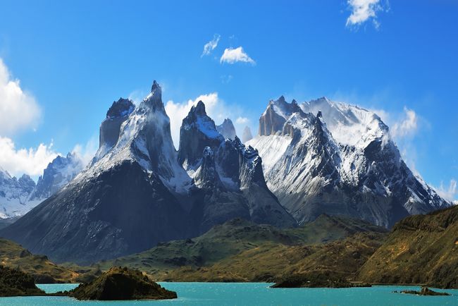
757) Andes Mountains
Andes Mountains, also called the Andes, Spanish Cordillera de los Andes or Los Andes, mountain system of South America and one of the great natural features of the Earth.
The Andes consist of a vast series of extremely high plateaus surmounted by even higher peaks that form an unbroken rampart over a distance of some 5,500 miles (8,900 kilometres)—from the southern tip of South America to the continent’s northernmost coast on the Caribbean. They separate a narrow western coastal area from the rest of the continent, affecting deeply the conditions of life within the ranges themselves and in surrounding areas. The Andes contain the highest peaks in the Western Hemisphere. The highest of them is Mount Aconcagua (22,831 feet [6,959 metres]) on the border of Argentina and Chile.
The Andes are not a single line of formidable peaks but rather a succession of parallel and transverse mountain ranges, or cordilleras, and of intervening plateaus and depressions. Distinct eastern and western ranges—respectively named the Cordillera Oriental and the Cordillera Occidental—are characteristic of most of the system. The directional trend of both the cordilleras generally is north-south, but in several places the Cordillera Oriental bulges eastward to form either isolated peninsula-like ranges or such high intermontane plateau regions as the Altiplano (Spanish: “High Plateau”), occupying adjoining parts of Argentina, Chile, Bolivia, and Peru.
Some historians believe the name Andes comes from the Quechuan word anti (“east”); others suggest it is derived from the Quechuan anta (“copper”). It perhaps is more reasonable to ascribe it to the anta of the older Aymara language, which connotes copper colour generally.
Physical Features
There is no universal agreement about the major north-south subdivisions of the Andes system. For the purposes of this discussion, the system is divided into three broad categories. From south to north these are the Southern Andes, consisting of the Chilean, Fuegian, and Patagonian cordilleras; the Central Andes, including the Peruvian cordilleras; and the Northern Andes, encompassing the Ecuadorian, Colombian, and Venezuelan (or Caribbean) cordilleras.
Geology
The Andean mountain system is the result of global plate-tectonic forces during the Cenozoic Era (roughly the past 65 million years) that built upon earlier geologic activity. About 250 million years ago the crustal plates constituting the Earth’s landmass were joined together into the supercontinent Pangaea. The subsequent breakup of Pangaea and of its southern portion, Gondwana, dispersed these plates outward, where they began to take the form and position of the present-day continents. The collision (or convergence) of two of these plates—the continental South American Plate and the oceanic Nazca Plate—gave rise to the orogenic (mountain-building) activity that produced the Andes.
Many of the rocks comprising the present-day cordilleras are of great age. They began as sediments eroded from the Amazonia craton (or Brazilian shield)—the ancient granitic continental fragment that constitutes much of Brazil—and deposited between about 450 and 250 million years ago on the craton’s western flank. The weight of these deposits forced a subsidence (downwarping) of the crust, and the resulting pressure and heat metamorphosed the deposits into more resistant rocks; thus, sandstone, siltstone, and limestone were transformed, respectively, into quartzite, shale, and marble.
Approximately 170 million years ago this complex geologic matrix began to be uplifted as the eastern edge of the Nazca Plate was forced under the western edge of the South American Plate (i.e., the Nazca Plate was subducted), the result of the latter plate’s westward movement in response to the opening of the Atlantic Ocean to the east. This subduction-uplift process was accompanied by the intrusion of considerable quantities of magma from the mantle, first in the form of a volcanic arc along the western edge of the South American Plate and later by the injection of hot solutions into surrounding continental rocks; the latter process created numerous dikes and veins containing concentrations of economically valuable minerals that later were to play a critical role in the human occupation of the Andes.
The intensity of this activity increased during the Cenozoic Era, and the present shape of the cordilleras emerged. The accepted time period for their rise had been from about 15 million to 6 million years ago. However, through the use of more advanced techniques, researchers in the early 21st century were able to determine that the uplift started much earlier, about 25 million years ago. The resultant mountain system exhibits an extraordinary vertical differential of more than 40,000 feet between the bottom of the Peru-Chile (Atacama) Trench off the Pacific coast of the continent and the peaks of the high mountains within a horizontal distance of less than 200 miles. The tectonic processes that created the Andes have continued to the present day. The system—part of the larger circum-Pacific volcanic chain that often is called the Ring of Fire—remains volcanically active and is subject to devastating earthquakes.
Physiography of the Southern Andes
The Fuegian Andes begin on the mountainous Estados (Staten) Island, the easternmost point of the Tierra del Fuego archipelago, reaching an elevation of 3,700 feet. They run to the west through Grande Island, where the highest ridges—including Mounts Darwin, Valdivieso, and Sorondo—are all less than 7,900 feet high. The physiography of this southernmost subdivision of the Andes system is complicated by the presence of the independent Sierra de la Costa.
The Patagonian Andes rise north of the Strait of Magellan. Numerous transverse and longitudinal depressions and breaches cut this wild and rugged portion of the Andes, sometimes completely; many ranges are occupied by ice fields, glaciers, rivers, lakes, or fjords. The crests of the mountains exceed 10,000 feet (Mount Fitzroy reaching 11,073 feet) north to latitude 46° S but average only 6,500–8,400 feet from latitude 46° to 41° S, except for Mount Tronador (11,453 feet). North of Lake Aluminé (Argentina) the axis of the cordillera shifts to the east up to a zone of transition between latitude 37° and 35° S, where the geographic aspect and geomorphic structure change. This zone marks the most commonly accepted northern extent of the Patagonian Andes; there is some disagreement, however, about this limit, some placing it farther south, at the Gulf of Penas, (47° S) and others considering it to be to the north, around 30° S.
The line of permanent snow becomes higher in elevation with decreasing latitude in the Southern Andes: 2,300 feet in Tierra del Fuego, 5,000 feet at Osorno Volcano (41° S), and 12,000 feet at Domuyo Volcano (36°38′ S). A line of active volcanoes—including Yate, Corcovado, and Macá—occurs about 40° to 46° S; the southernmost of these, Mount Hudson of Chile, erupted in 1991. Enormous ice fields are located between Mount Fitzroy (called Mount Chaltel in Chile) and Lake Buenos Aires (Lake General Carrera in Chile) at both sides of Baker Fjord; the Viedma, Upsala, and other glaciers originate from these fields. Other notable features are the more than 50 lakes found south of 39° S. Those depressions that are free of water form fertile valleys called vegas, which are easily reached by low passes. Magnificent and impenetrable forests grow on both sides of these cordilleras, especially on the western slopes; these forests cover the mountains as high as the snow line, although at the higher altitudes toward the north and in Tierra del Fuego the vegetation is lower and less dense. Both Argentina and Chile have created national parks to preserve the area’s natural beauty.
Physiography of the Central Andes
The Central Andes begin at latitude 35° S, at a point where the cordillera undergoes a sharp change of character. Its width increases to about 50 miles, and it becomes arid and higher; the passes, too, are higher and more difficult to cross. Glaciers are rare and found only at high elevations. The main range serves as the boundary between Chile and Argentina and also is the drainage divide between rivers flowing to the Pacific and the Atlantic. The last of the southern series of volcanoes, Mount Tupungato (21,555 feet) is just east of Santiago, Chile. A line of lofty, snowcapped peaks rise between Tupungato and the mighty Mount Aconcagua. To the north of Aconcagua lies Mount Mercedario (22,211 feet), and between them are the high passes of Mount Espinacito (16,000 feet) and Mount Patos (12,825 feet). South of Anconcagua the passes include Pircas (16,960 feet), Bermejo (more than 10,000 feet), and Iglesia (13,400 feet). Farther north the passes are more numerous but higher. The peaks of Mounts Bonete, Ojos del Salado, and Pissis surpass 20,000 feet.
The peak of Tres Cruces (22,156 feet) at 27° S latitude marks the culmination of this part of the cordillera. To the north is found a transverse depression and the southern limit of the high plateau region called the Atacama Plateau in Argentina and Chile and the Altiplano in Bolivia and Peru. The cordillera grows wider as it advances into Bolivia and Peru, where the great plateau is bounded by two ranges: the Occidental and the Oriental.
Northward, to latitude 18° S, the peaks of El Cóndor, Sierra Nevada, Llullaillaco, Galán, and Antofalla all exceed 19,000 feet. The two main ranges and several volcanic secondary chains enclose depressions called salars because of the deposits of salts they contain; in northwestern Argentina, the Sierra de Calalaste encompasses the large Antofalla Salt Flat. Volcanoes of this zone occur mostly on a northerly line along the Cordillera Occidental as far as Misti Volcano (latitude 16° S) in Peru.
The western slopes of the Cordillera Occidental descend gradually to the Atacama Desert along the coast. At about 18° S the trend of the Cordillera Occidental changes to a northwesterly direction. The Cordillera Oriental to the east, lower and built on a broad bed of lava, is cut and denuded by rivers with steep gradients, fed by heavy rainfall. It has two sections. The southern portion is 150 miles wide and—with the exception of Chorolque Peak in Bolivia (18,414 feet)—of relatively low elevation. The northern section in Bolivia, called Cordillera Real, is narrow, with higher peaks and glaciers; the most important peaks, at over 21,000 feet, are Mounts Illimani and Illampu.
At about latitude 22° S the Cordillera Oriental penetrates into Bolivia and describes a wide semicircle to the north and then to the northwest; to the west the Altiplano reaches its broadest extent. The Altiplano—500 miles long and 80 miles wide—is one of the largest interior basins of the world. Varying in elevation from 11,200 to 12,800 feet, it has no drainage outlet to the ocean. Roughly in the centre of the plateau is a great depression between the two cordilleras. Lake Titicaca, the highest navigable lake of the world (110 miles long), fills the northern part of the depression; the Desaguadero River flows south through the depression, draining Titicaca water into the smaller Lake Poopó.
As the Andes enter Peru, the Cordillera Occidental runs parallel to the coast, while the Cordillera Real from Bolivia ends in the rough mountain mass of the Vilcanota Knot at latitude 15° S. From this knot (nudo), two lofty and narrow chains emerge northward, the Cordilleras de Carabaya and Vilcanota, separated by a deep gorge; a third range, the Cordillera de Vilcabamba, appears to the west of these and northwest of the city of Cuzco. The three ranges are products of erosive action of rivers that have cut deep canyons between them. West of the Cordillera de Vilcabamba, the Apurímac River runs in one of the deepest canyons of the Western Hemisphere. The city of Cuzco lies in the valley west of the Cordillera de Vilcanota at an altitude of nearly 11,000 feet.
The Peruvian Andes traditionally have been described as three cordilleras, which come together at the Vilcanota, Pasco, and Loja (Ecuador) knots. The Pasco Knot is a large, high plateau. To the west it is bounded by the Cordillera Huarochirí, on the west slope of which the Rímac River rises in a cluster of lakes fed by glaciers and descends rapidly to the ocean (15,700 feet in 60 miles). Ticlio Pass, at an altitude of some 15,800 feet, is used by a railway. Many small lakes and ponds are found on the knots, with Lake Junín (about 20 miles long) being the largest.
North of the Pasco Knot, three different ranges run along the plateau: the Cordilleras Occidental, Central, and Oriental. In the Cordillera Occidental, at latitude 10° S, the deep, narrow Huaylas Valley separates two ranges, Cordillera Blanca to the east and Cordillera Negra to the west; the Santa River runs between them and cuts Cordillera Negra to drain into the Pacific. Cordillera Blanca is a complex highland with permanently snowcapped peaks, some among the highest of the Andes (e.g., Mount Huascarán, at 22,205 feet). At times, the glaciers that rise there are broken off by earthquakes and rush down the slopes, demolishing vegetation and settlements in their paths. Cordillera Negra, so named because it is not covered with snow, is lower.
The two ranges join together at latitude 9° S. The Marañón River, which runs northward between the Cordilleras Occidental and Central at about 6° S, changes its direction of flow to the northeast, penetrating into a region of narrow transverse water gaps (pongos) that cut the cordillera to reach the Amazon basin. These include Rentema (about one and one-fourth miles long and 200 feet wide), Mayo, Mayasito, and Huarcaya gaps and—the most important—Manseriche Gap, which is seven miles long.
Between the Cordilleras Central and Oriental, the Huallaga River runs in a deep gorge with few small valleys; it cuts the eastern cordillera at Aguirre Gap (latitude 6° S). The Cordillera Oriental ends in the Amazon basin at 5° S.
The permanent snow line reaches an altitude of 19,000 feet in Mount Chanchani (about latitude 16° S) and declines to about 15,000 feet in Cordillera Blanca and to 13,000 feet on Mount Huascarán. Permanent snow is less common north of 8° S, the puna grasslands end, and the so-called humid puna, or jalca, begins. Mountains become wider and smoother in appearance, while vegetation changes to heathland and trees. The altitude diminishes, and passes are much lower, as at Porculla Pass (7,000 feet) east of Piura.
Physiography of the Northern Andes
A rough and eroded high mass of mountains called the Loja Knot (4° S) in southern Ecuador marks the transition between the Peruvian cordilleras and the Ecuadorian Andes. The Ecuadorian system consists of a long, narrow plateau running from south to north bordered by two mountain chains containing numerous high volcanoes. To the west, in the geologically recent and relatively low Cordillera Occidental, stands a line of 19 volcanoes, 7 of them exceeding 15,000 feet in elevation. The eastern border is the higher and older Cordillera Central, capped by a line of 20 volcanoes; some of these, such as Chimborazu Volcano (20,702 feet), have permanent snowcaps.
The outpouring of lava from these volcanoes has divided the central plateau into 10 major basins that are strung in beadlike fashion between the two cordilleras. These basins and their adjacent slopes, which are intensively cultivated, contain roughly half of Ecuador’s population.
A third cordillera has been identified in the eastern jungle of Ecuador and has been named the Cordillera Oriental. The range appears to be an ancient alluvial formation that has been divided by rivers and heavy rainfall into a number of mountain masses. Such masses as the cordilleras of Guacamayo, Galeras, and Lumbaquí are isolated or form irregular short chains and are covered by luxuriant forest. Altitudes do not exceed 7,900 feet, except at Cordilleras del Cóndor (13,000 feet) and Mount Pax (11,000 feet).
North of the boundary with Colombia is a group of high, snowcapped volcanoes (Azufral, Cumbal, Chiles) known as the Huaca Knot. Farther to the north is the great massif of the Pasto Mountains (latitude 1°–2° N), which is the most important Colombian physiographic complex and the source of many of the country’s rivers.
Three distinct ranges, the Cordilleras Occidental, Central, and Oriental, run northward. The Cordillera Occidental, parallel to the coast and moderately high, reaches an elevation of nearly 13,000 feet at Mount Paramillo before descending in three smaller ranges into the lowlands of northern Colombia. The Cordillera Central is the highest (average altitude of almost 10,000 feet) but also the shortest range of Colombian Andes, stretching some 400 miles before its most northerly spurs disappear at about latitude 8° N.
Most of the volcanoes of the zone are in this range, including Mounts Tolima (17,105 feet), Ruiz (17,717 feet), and Huila (18,865 feet). At about latitude 6° N, the range widens into a plateau on which Medellín is situated.
Between the Cordilleras Central and Occidental is a great depression, the Patía-Cauca valley, divided into three longitudinal plains. The southernmost is the narrow valley of the Patía River, the waters of which flow to the Pacific. The middle plain is the highest in elevation (8,200 feet) and constitutes the divide of the other two. The northern plain, the largest (15 miles wide and 125 miles long), is the valley of Cauca River, which drains northward to the Magdalena River.
The Cordillera Oriental trends slightly to the northeast and is the widest and the longest of the three. The average altitude is 7,900 to 8,900 feet. North of latitude 3° N the cordillera widens and after a small depression rises into the Sumapaz Uplands, which range in elevation from 10,000 to 13,000 feet. North of the Sumapaz Upland the range divides into two, enclosing a large plain 125 miles wide and 200 miles long, often interrupted by small transverse chains that form several upland basins called sabanas that contain about a third of Colombia’s population. The city of Bogotá is on the largest and most populated of these sabanas; other important cities on sabanas are Chiquinquirá, Tunja, and Sogamoso. East of Honda (5° N) the cordillera divides into a series of abrupt parallel chains running to the north-northeast; among them the Sierra Nevada del Cocuy (18,022 feet) is high enough to have snowcapped peaks.
Farther north the central ranges of the Cordillera Central come to an end, but the flanking chains continue and diverge to the north and northeast. The westernmost of these chains is the Sierra de Ocaña, which on its northeastern side includes the Sierra de Perijá; the latter range forms a portion of the boundary between Colombia and Venezuela and extends as far north as latitude 11° N in La Guajira Peninsula. The eastern chain bends to the east and enters Venezuela as the Cordillera de Mérida. On the Caribbean coast just west of the Sierra de Perijá stands the isolated, triangular Santa Marta Massif, which rises abruptly from the coast to snowcapped peaks of 18,947 feet; geologically, however, the Santa Marta Massif is not part of the Andes.
The Venezuelan Andes are represented by the Cordillera de Mérida (280 miles long, 50 to 90 miles wide, and about 10,000 feet in elevation), which extends in a northeasterly direction to the city of Barquisimeto, where it ends. The cordillera is a great uplifted axis where erosion has uncovered granite and gneiss rocks but where the northwestern and southeastern flanks remain covered by sediments; it consists of numerous chains with snow-covered summits separated by longitudinal and transverse depressions—Sierras Tovar, Nevada, Santo Domingo, de la Culata, Trujillo, and others. The range forms the northwestern limit of the Orinoco River basin, beyond which water flows to the Caribbean. North of Barquisimeto, the Sierra Falcón and Cordillera del Litoral (called in Venezuela the Sistema Andino) do not belong to the Andes but rather to the Guiana system.
Soils
The complex interchange between climate, parent material, topography, and biology that determines soil types and their condition is deeply affected by altitude in the Andes. In general, Andean soils are relatively young and are subject to great erosion by water and winds because of the steep gradients of much of the land.
In the Fuegian and southern Patagonian Andes, the formation of soils is difficult; the actions of glaciers and of strong winds have left nearly bare rock in many places. Peat bogs, podzols, and meadow soils, all with thick horizons (layers) of humus, are found; drainage is poor. Volcanic soils that are rich in organic material and are well drained occur in the region of lakes. North of latitude 45° S, soils are formed directly on weathered rocks at higher elevations, and reddish brown soils with gravel and quartz are found in the lower zones; erosion is heavy.
North of 37° S the Atacama Desert is covered with heavily eroded desertic soils that are low in moisture and organic material and high in mineral salts. This soil type, with few differences, extends along the Cordillera Occidental to north of Peru.
From Bolivia to Colombia the soils of the plateau and the east side of the eastern cordilleras show characteristics closely related to altitude. In the Andean páramo embryonic soils black with organic material are found. At altitudes between 6,000 and 12,000 feet, red, brown, and chernozem soils occur on moderate slopes and on basin floors. In more poorly drained locations, soils with a permeable sandy horizon are relatively fertile; these soils are the most economically important in Bolivia, Peru, and Ecuador.
The sabana soils of Colombia are gray-brown, with an impermeable claypan in certain levels, resulting in poor drainage.
At high elevations soils are thin and stony. On the east side of the eastern cordilleras, descending to the Amazon basin, thin, poorly developed humid soils are subject to considerable erosion. Intrazonal soils (those with weakly developed horizons) include humic clay and solonetz (dark alkaline soils) types found close to lakes and lagoons. Also included in this group are soils formed from volcanic ash in the Cordillera Occidental from Chile to Ecuador.
The azonal soils—alluvials (soils incompletely evolved and stratified without definite profile) and lithosols (shallow soils consisting of imperfectly weathered rock fragments)—occupy much of the Andean massif. In Colombia, sandy yellow-brown azonal soils on slopes and in gorges are the base of the large coffee plantations.
Climate
In general, temperature increases northward from Tierra del Fuego to the Equator, but such factors as altitude, proximity to the sea, the cold Peru (Humboldt) Current, rainfall, and topographic barriers to the wind contribute to a wide variety of climatic conditions. The hottest rain forests and deserts often are separated from tundralike puna by a few miles. There also is considerable climatic disparity between the external slopes (i.e., those facing the Pacific or the Amazon basin) and the internal slopes of the cordilleras; the external slopes are under the influence of either the ocean or the Amazon basin. As mentioned above, the line of permanent snow varies greatly. It increases from 2,600 feet at the Strait of Magellan, to 20,000 feet at latitude 27° S, after which it begins descending again until it reaches 15,000 feet in the Colombian Andes.
Precipitation varies widely. South of latitude 38° S, annual precipitation exceeds 20 inches, whereas to the north it diminishes considerably and becomes markedly seasonal. Farther north—on the Altiplano of Bolivia, the Peruvian plateau, and in the valleys of Ecuador and the sabanas of Colombia—rainfall is moderate, though amounts are highly variable. It rains only in very small amounts on the west side of the Peruvian Cordillera Occidental but considerably more in Ecuador and Colombia. On the east (Amazonian) side of the Cordilleras Orientales, rainfall usually is seasonal and heavy.
Temperature varies greatly with altitude. In the Peruvian and Ecuadorian Andes, for example, the climate is tropical up to an altitude of 4,900 feet, becoming subtropical up to 8,200 feet; hot temperatures prevail during the day, and nights are mildly warm. Between 8,200 and 11,500 feet daytime temperatures are mild, but there are marked differences between night and day; this zone constitutes the most hospitable area of the Andes. From 11,500 to 14,800 feet it generally is cold—with great differences between day and night and between sunshine and shadow—and temperatures are below freezing at night. Between about 13,500 and 15,700 feet (the puna), the climate of the páramo is found, with constant subfreezing temperatures. Finally, above 15,700 feet, the climate of the peaks and high ridges is polar with extremely low temperatures and icy winds.
As in other mountainous areas of the world, a wide variety of microclimates (highly localized climatic conditions) exist because of the interplay of aspect, exposure to winds, latitude, length of day, and other factors. Peru, in particular, has one of the world’s most complex arrays of habitats because of its numerous microclimates.
Plant and animal life
The ability of plants and animals to live in the Andes varies with altitude, although the existence of plant communities is also determined by climate, availability of moisture, and soil, while that of animal life is also affected by the abundance of food sources; the permanent snow line is the upper limit of habitation. Some plants and animals can live at any altitude, and others can live only at certain levels. Cats rarely live above 13,000 feet, whereas white-tailed mice usually do not stay lower than 13,000 feet and can live up to 17,000 feet. The camelids (llama, guanaco, alpaca, and vicuña) are animals primarily of the Altiplano (11,200 to 12,800 feet), although they can live well at lower altitudes. It is thought that the condor can fly up to 26,000 feet.
Probably the low barometric pressures of high altitudes are less important for vegetation, but altitude amplifies a number of climatic variables—such as temperature, wind, radiation, and dryness—that determine what kinds of plants grow in different parts of the Andes. In general, the Andes can be divided into altitudinal bands, each with typical predominant vegetation and fauna; but latitude imposes differences between south and north, and proximity to the Pacific and to the Amazon basin is reflected in differences between the external and internal slopes of the Cordilleras Occidental and Oriental.
A zone at about latitude 35° S separates two different regions of the Andes. To the south, in the Patagonian Andes, the flora is austral (of southern aspect) instead of Andean. Magnificent mid-latitude rain forests of the conifer genus Araucaria and of oak, coigue (an evergreen used for thatching), chusquea, cypress, and larch occur.
Characteristics to the north are different. The Cordillera Occidental is extremely dry in the south, slightly humid (with moisture and scarce rainfall) in central and northern Peru, and humid with heavy or moderate rainfall in Ecuador and Colombia. Vegetation follows the climatic scheme: in the south it is poor and desertlike, though at higher altitudes steppe vegetation occurs. Animals include the guemul, puma, vizcacha, cuy (guinea pig), chinchilla, camelids, mice, and lizards; among the birds are the condor, partridge, parina, huallata, and coot. Excluding areas where irrigation methods are utilized, agricultural potential is poor. The east side of the Cordilleras Orientales northward from Bolivia has lush vegetation, most of it tropical forest with a rich jungle fauna.
On the plateau (valleys, plains, ranges, and internal slopes of the cordilleras), life again is closely related to altitude. Tropical palms and eternal snows lie within a few miles of each other, where altitude may vary from 1,600 feet in deep gorges to more than 20,000 feet in peaks and ridges. Up to an elevation of 8,000 feet, vegetation reflects the dry tropical and subtropical climate, and agriculture is important: the great coffee industry of Colombia is located mainly in the warm valleys of this zone. Between 8,200 and 11,500 feet lies the most populated zone of the Andes; some of the major cities of the Andean countries are there, and the zone supports the main part of Andean agriculture. Temperatures vary from warm in the valleys to moderate low (down to 50 °F [10 °C]) on the plains, sabanas, and slopes, and there is seasonal rainfall and water from rivers. This zone also is suitable for livestock and poultry farming.
Between 11,500 and 13,400 feet relief is usually rough and difficult for agriculture. In Colombia this zone is páramo and sub-páramo, with seasonal rainfall; in Ecuador rain is abundant; and in Peru páramo has from moderate to scarce rainfall. From 13,400 to 15,700 feet (the puna), vegetation consists of plants that resist the cold temperature and nighttime freezing; above 16,000 feet, vegetation is almost absent.
The People
Human presence in the Andes is relatively recent; the oldest human remains to be found are only 10,000 to 12,000 years old, although habitation probably dates to much earlier times. The shortage of oxygen at high altitude, especially above 12,000 feet, is so physiologically demanding that it imposes deep adaptative changes even within the cells of the body. The highest altitude in the Andes at which people have resided permanently is 17,100 feet (shepherds in southern Peru) and, as temporary workers, 18,500 to 19,000 feet (Carrasco Mine, in the Atacama Desert, Chile).
From Patagonia to the southern limits of the Bolivian Altiplano, the Andes are sparsely populated; a few small groups of shepherds and farmers live on the lower slopes and vegas of the cordillera. Farther to the north, from Bolivia to Colombia, the largest population concentrations and most of the important cities of these countries are found in the Andes. In Peru and Bolivia, a significant proportion of the inhabitants live above 10,000 feet.
Roughly half the population of Bolivia are Aymara- and Quechua-speaking Indians; most of the remainder are Spanish-speaking mestizos (or mixed). In the Lake Titicaca district live remnants of the ancient Uru people. Population is distributed mainly between the high páramos, where, except for a seminomad population of shepherds, the principal occupation is mining, and the lower narrow valleys, where the people practice agriculture. In Peru, mining is the most important human activity above 11,500 feet, but the great majority of the Andean population is engaged in agriculture and raising sheep, cattle, goats, llamas, and alpacas; a growing proportion of people have become employed in industry and commerce. A group of Aymara-speaking Indians live in the south around Lake Titicaca, but the largest native population is Quechua-speaking; Quechua speakers constitute the great majority of the highland population.
The inhabitants of the Ecuadorian Andes are mainly Quechua speakers and mestizos; in the south there are small groups of Cañaris and, in the north, Salasacas. Agriculture (corn [maize], potatoes, broad beans) is the main occupation; some Indian peoples engage in ceramics and weaving.
In Colombia the largest proportion of the population lives between 5,000 and 10,500 feet. Only a tiny fraction of the country’s population is Indian, these groups living on the Altiplano of the Cordillera Oriental and in the Cordillera Central and the southern mountains. The zone of coffee plantations at about 3,000 to 6,500 feet is the most densely populated area.
The Economy
Agriculture and livestock
Agriculture on the Andes is difficult, and crop yields are relatively poor. The water supply is inadequate, and a large part of the plateau region is dry or receives little and irregular seasonal rainfall. Temperatures of the high plains are cold, and crops are subject to freezing. The terrain is rough, and soils are not well developed; and, where fertile valleys do occur, they are narrow and small. Terraced fields have been developed on many slopes to increase the amount of land available for agriculture.
Thus, a considerable amount of Andean agricultural production is for local consumption. Some products, however, have been grown in sufficient quantity to be exported, including coffee (especially from Colombia), tobacco, and cotton; in addition, large quantities of coca (the source of cocaine) have been exported from Colombia and Bolivia, despite efforts to curb production. The possibilities of increasing the amount of arable land area by irrigation are extremely limited.
The natural pastures of the plateau regions are extensively used for cattle raising. Colombia exports cattle, and Peru has a large milk-canning and livestock industry. Sheep, goat, llama, and alpaca raising are widespread in Peru and Bolivia, with both countries exporting sheep and alpaca wool.
Mining
The mining industry of the Andes is one of the most important of the world. Mining is especially extensive in the south. The principal minerals are copper in Chile and Peru; tin in Bolivia; silver, lead, and zinc in Bolivia and Peru; gold in Peru, Ecuador, and Colombia; platinum and emeralds in Colombia; bismuth in Bolivia; vanadium in Peru; and coal and iron in Chile, Peru, and Colombia. Several deposits of petroleum are distributed along the eastern side of the Andes.
Transportation
The Andes always have been a formidable barrier for communication, with great effect on the economic and cultural development of the region. Production centres generally are far from seaports, and the mountainous character of the land makes the construction and maintenance of railways and roads difficult and expensive. A large network of pack trails are still in use between small communities and between farms and markets. Horses, donkeys, and mules are widely used; in Colombia the ox and in Peru and Bolivia the llama also are transport animals.
Most of the railways were built to transport mining products, and otherwise are little developed. There are two international railways between Chile and Argentina: the first connects Valparaíso and Buenos Aires, and the second, Antofagasta and Salta. La Paz, Bolivia, is connected with Buenos Aires, Antofagasta and Arica (Chile), and (via Lake Titicaca) Puno, Arequipa, Cuzco, and Matarani (Peru). Peru has two important internal railways, one from Puno to Cuzco and the other from Lima to Cerro de Pasco and Huancavelica; the latter line is the highest in the world, crossing Ticlio Pass at an altitude of some 15,800 feet. The main rail line in Ecuador runs from Quito to Guayaquil, and in Colombia the main line connects Bogotá to the Caribbean coast.
Roads are more suitable for Andean agricultural regions, because the small and widely separated valleys make railway construction and operation too expensive. Since World War II, all countries along the Andean cordilleras have expanded their road networks both within and through the mountains, although only a small portion of these roads are paved. The Pan-American Highway connects the major western cities; various east-west routes are included in the system.
Air transport has become particularly important in the Andes, where it has reduced the difficulties of overland communication. Air routes are especially well developed in Colombia and Peru.
Study And Exploration
As mentioned above, the Andes have been populated for millennia. By the time of the Spanish conquest in the 1530s, the indigenous highland peoples had developed a thorough knowledge of the Andes and had built in them an extensive network of cities and connecting roads. Early Spanish exploration of the mountains consisted of plundering raids, although in the process most of the major modern Andean cities were founded.
The first systematic European study of the mountains came in the form of a series of surveys called the Relaciones geográficas (1579–85), which in increasingly elaborate questionnaires recorded much geographic and economic information about Spain’s overseas colonies. In 1735 an expedition led by the French naturalist Charles-Marie de La Condamine began to measure the arc of the meridian at the Equator in the Andes, and for several years this group surveyed the Ecuadorian ranges. An even more important series of investigations was conducted by the German naturalist and explorer Alexander von Humboldt, who arrived on the Venezuelan coast in 1799 and for five years made innumerable observations of Andean geology, climatology, and biology (particularly of altitude-based ecological zones).
By the mid-19th century the now-independent Andean countries were conducting and sponsoring scientific exploration of the mountains. Among those active at that time were the British mountaineer Edward Whymper in Ecuador, the Peruvian Mariano Paz Soldan in Peru, and the Italian geographer Agostino Codazzi, who produced detailed maps of Colombia and Venezuela. Since the late 19th century much Andean research has been directed toward economic development, primarily mining operations and railway construction.
It appears to me that if one wants to make progress in mathematics, one should study the masters and not the pupils. - Niels Henrik Abel.
Nothing is better than reading and gaining more and more knowledge - Stephen William Hawking.
Offline
#780 2020-09-06 00:54:53
- Jai Ganesh
- Administrator
- Registered: 2005-06-28
- Posts: 51,576
Re: Miscellany
758) Atacama Desert
Atacama Desert, Spanish Desierto de Atacama, cool, arid region in northern Chile, 600 to 700 miles (1,000 to 1,100 km) long from north to south. Its limits are not exactly determined, but it lies mainly between the south bend of the Loa River and the mountains separating the Salado-Copiapó drainage basins. To the north the desert continues to the border of Peru.
A line of low coastal mountains, the Cordillera de la Costa, lies to the west of the desert, and to its east rises the Cordillera Domeyko, foothills of the Andes. The desert consists mainly of salt pans at the foot of the coastal mountains on the west and of alluvial fans sloping from the Andean foothills to the east; some of the fans are covered with dunes, but extensive pebble accumulations are more common.
The coastal chain hovers around 5,000 feet (1,500 metres) or so in elevation with individual peaks reaching to 6,560 feet (2,000 metres). There is no coastal plain. Through much of their extent the mountains terminate abruptly at the sea in cliffs, some of them higher than 1,600 feet (500 metres), making communication difficult between the coastal ports and the interior. In the interior a raised depression extends north and south and forms the high Tamarugal Plain at an elevation of more than 3,000 feet (900 metres). Farther to the east in the western outliers of the Andes, preceded by the Cordillera Domeyko, there are numerous volcanic cones, some exceeding 16,000 feet (4,900 metres) in elevation. Along Chile’s northeastern frontier with Argentina and Bolivia extends the Atacama Plateau, which reaches elevations of 13,000 feet (4,000 metres).
The Atacama Desert forms part of the arid Pacific fringe of South America. Dry subsidence created by the South Pacific high-pressure cell makes the desert one of the driest regions in the world. Along the coast the aridity is also a consequence of the Peru (Humboldt) Current, which is characterized by upwelling (the upward movement of cold water from the depths of the ocean); the resulting cold water at the surface causes a thermal inversion—cold air at sea level and stable warmer air higher up. This condition produces fog and stratus clouds but no rain. Rains fall in Iquique or Antofagasta only when powerful southern fronts break into the subsidence area. Temperatures in the desert are relatively low compared with those in similar latitudes elsewhere. The average summer temperature at Iquique is only 66 °F (19 °C) and at Antofagasta 65 °F (18 °C).
The original inhabitants of the region were Atacameño, an extinct Indian culture, different from the Aymara to the north and the Diaguita to the south. For much of the 19th century, the desert was the object of conflicts among Chile, Bolivia, and Peru because of its mineral resources, particularly sodium nitrate deposits located northeast of Antofagasta and inland from Iquique. Much of the area originally belonged to Bolivia and Peru, but the mining industry was controlled by Chilean and British interests, which were strongly supported by the Chilean government. From the War of the Pacific (1879–83), Chile emerged victorious. The Treaty of Ancón (1883) gave Chile permanent ownership of sectors previously controlled by Peru and Bolivia, the latter losing its whole Pacific coastline.
The area proved to be one of the chief sources of Chile’s wealth until World War I. Nitrate deposits in the central depression and in several basins of the coastal range were systematically mined after the mid-19th century. Ports were built at Iquique, Caldera, Antofagasta, Taltal, Tocopilla, Mejillones, and, farther north, Pisagua, and railroads penetrated the mountain barriers to the interior. Prior to World War I, Chile had a world monopoly on nitrate; in some years 3,000,000 tons were extracted, and the taxes on its export amounted to half the government’s revenues. The development of synthetic methods of fixing nitrogen have since reduced the market to a regional one. Some sulfur is still mined in the high Cordillera. The region’s chief source of revenue, however, is copper mining at Chuquicamata in the Calama basin.
Some farming is done in the desert’s river oases, but this supports only a few thousand traditional cultivators. Lemons are grown at Pica, and a variety of products are cultivated on the shores of the salt marshes at San Pedro de Atacama. At Calama, near Chuquicamata, water from the Loa River irrigates potato and alfalfa fields.

It appears to me that if one wants to make progress in mathematics, one should study the masters and not the pupils. - Niels Henrik Abel.
Nothing is better than reading and gaining more and more knowledge - Stephen William Hawking.
Offline
#781 2020-09-07 00:26:17
- Jai Ganesh
- Administrator
- Registered: 2005-06-28
- Posts: 51,576
Re: Miscellany
759) Lord's Cricket Ground
Lord’s Cricket Ground, headquarters and home ground of the Marylebone Cricket Club, long the world’s foremost cricket organization, and the scene of Test Matches between England and visiting national teams and of matches of the Middlesex County Cricket Club, Oxford versus Cambridge, and Eton versus Harrow. Various cup finals and one-day international matches also take place there. The original Lord’s was established in 1787 at Dorset Square, St. Marylebone, southwest of Regent’s Park, London, by Thomas Lord. In 1811 it was moved to St. John’s Wood Estate and in 1814 to the present site, at St. John’s Wood Road west of Regent’s Park. Lord’s is also the headquarters of the International Cricket Council (the world governing body) and of the Cricket Council and the Test and County Cricket Board, which control English cricket. Around the world, Lord’s is known as the “home” of cricket and of cricketers.
Marylebone Cricket Club
Marylebone Cricket Club (MCC), former governing body of cricket, founded in London in 1787. Marylebone soon became the leading cricket club in England and, eventually, the world authority on laws. The MCC headquarters are at Lord’s Cricket Ground in London. The Cricket Council is now the final arbiter in England, as are boards of control in other countries, with the International Cricket Conference exercising advisory jurisdiction over world cricket affairs.
First Test : England v Australia - Jul 21-23, 1884.
Lord's Cricket Ground, commonly known as Lord's, is a cricket venue in St John's Wood, London. Named after its founder, Thomas Lord, it is owned by Marylebone Cricket Club (MCC) and is the home of Middlesex County Cricket Club, the England and Wales Cricket Board (ECB), the European Cricket Council (ECC) and, until August 2005, the International Cricket Council (ICC). Lord's is widely referred to as the Home of Cricket and is home to the world's oldest sporting museum.
Lord's today is not on its original site; it is the third of three grounds that Lord established between 1787 and 1814. His first ground, now referred to as Lord's Old Ground, was where Dorset Square now stands. His second ground, Lord's Middle Ground, was used from 1811 to 1813 before being abandoned to make way for the construction through its outfield of the Regent's Canal. The present Lord's ground is about 250 yards (230 m) north-west of the site of the Middle Ground. The ground can hold 30,000 spectators. Proposals are being developed to increase capacity and amenity. As of December 2013, it was proposed to redevelop the ground at a cost of around £200 million over a 14-year period.
The current ground celebrated its two hundredth anniversary in 2014. To mark the occasion, on 5 July an MCC XI captained by Sachin Tendulkar played a Rest of the World XI led by Shane Warne in a 50 overs match.
Early history
Acting on behalf of the White Conduit Club and backed against any losses by George Finch, 9th Earl of Winchilsea and Colonel Charles Lennox, Thomas Lord opened his first ground in May 1787 on the site where Dorset Square now stands. The White Conduit moved there from Islington soon afterwards and reconstituted themselves as Marylebone Cricket Club (MCC). In 1811, feeling obliged to relocate because of a rise in rent, Lord removed his turf and relaid it at his second ground. This was short-lived because it lay on the route decided by Parliament for the Regent's Canal.
The "Middle Ground" was on the estate of the Eyre family, who offered Lord another plot nearby; and he again relocated his turf. The new ground, on the present site, was opened in the 1814 season. The earliest known match was MCC v Hertfordshire on 22 June 1814. This is not rated a first-class match. MCC won by an innings and 27 runs. The next match known to have been played at Lord's, from 13 to 15 July 1814, was the earliest first-class one, between MCC and the neighbouring St John's Wood club, which had several guest players for the occasion, including five leading professionals. MCC won by 4 wickets.
The annual Eton v Harrow match was first played on the Old Ground in 1805. There is no record of the fixture being played again until 29 July 1818, when it was held at the present Lord's ground for the first time; Harrow won by 13 runs. From 1822, the fixture has been almost an annual event at Lord's.
Ground
Stands
Many of the stands were rebuilt in the late 20th century. In 1987 the new Mound Stand, designed by Michael Hopkins and Partners, was opened, followed by the Grand Stand (by Nicholas Grimshaw) in 1996. The Media Centre, opposite the Pavilion between the Compton and Edrich Stands, was added in 1998–9; designed by Future Systems it won the Royal Institute of British Architects' Stirling Prize for 1999. The ground can currently hold up to 28,000 spectators. The two ends of the pitch are the Pavilion End (south-west), where the main members' pavilion is located, and the Nursery End (north-east), dominated by the Media Centre.
Pavilion
The main survivor from the Victorian era is the Pavilion, with its famous Long Room; this was built in 1889–90 to the designs of architect Thomas Verity. This historic landmark— a Grade II*-listed building— underwent an £8 million refurbishment programme in 2004–05. The pavilion is primarily for members of MCC, who may use its amenities, which include seats for viewing the cricket, the Long Room and its Bar, the Bowlers Bar, and a members' shop. At Middlesex matches the Pavilion is open to members of the Middlesex County Club. The Pavilion also contains the dressing rooms where players change, each of which has a small balcony for players to watch the play. In each of the two main dressing rooms are honours boards which commemorate all the centuries scored in Test matches or One Day Internationals (ODI) at Lord's, all instances of a bowler taking five wickets in a Test or ODI innings and all occurrences of a bowler taking ten wickets in a Test match.
The only cricketer to hit a ball over the pavilion was Albert Trott, off Monty Noble on 31 July 1899.
Media Centre
The Media Centre was commissioned in time for the 1999 Cricket World Cup, and was the first all-aluminium, semi-monocoque building in the world. It was built and fitted out in two boatyards, using boat-building technology. The centre stands 15 metres (49 ft) above the ground and its sole support comes from the structure around its two lift shafts— it is about the same height as the Pavilion directly opposite it on the other side of the ground. The lower tier of the centre provides accommodation for over 100 journalists, and the top tier has radio and television commentary boxes. The centre's only opening window is in the broadcasting box used by BBC Test Match Special. The building was awarded the RIBA Stirling Prize for architecture in 1999.
Tavern Stand
The Lord's Taverners, a charitable group comprising cricketers and cricket-lovers, take their name from the old Tavern pub at Lord's, where the organisation's founders used to congregate. The pub no longer exists, and the Tavern Stand now stands on its former site. However, a new pub of the same name is open in the grounds, as well as the Members Bar, in the Pavilion.
Field
One of the most distinctive and famous features of the Lord's ground is the significant slope across the field. The north-west side of the playing surface is 2.5 metres (8 ft 2 ins) higher than the south-east side. This slope causes appreciable deviation in bounce of the ball on the pitch, making it easier to move the ball in to right-handed batsmen when bowling from the Pavilion End, and easier to move it away when bowling from the Nursery End. The outfield was notorious for becoming waterlogged, resulting in considerable loss of play due to rainfall, until clay soil was relaid with sand during the winter of 2002–2003.
Grace Gates
Another feature of the ground is the pair of ornamental gates, named in honour of W. G. Grace. In 1923, the W. G. Grace Memorial Gates were erected at the St John's Wood Road entrance to the ground. They were designed by Sir Herbert Baker and the opening ceremony was performed by Sir Stanley Jackson, who had suggested the inclusion of the words The Great Cricketer in the dedication.
Floodlights
Temporary floodlights were installed at the ground in 2007, but were removed in 2008 after complaints of light pollution from local residents. In January 2009, Westminster City Council approved use of new retractable floodlights designed to minimise light spillage into nearby homes. Conditions of the approval included a five-year trial period during which up to 12 matches and 4 practice matches could be played under the lights from April to September. The lights must be dimmed to half-strength at 9.50 pm and be switched off by 11 pm. The floodlights were first used successfully on 27 May 2009 during the Twenty20 Cup match between Middlesex and Kent.
Cricket matches
Lord's hosts Test matches, one-day internationals, most Middlesex home matches, MCC matches and (starting with a fixture between Middlesex and Surrey in July 2004) some of Middlesex's home Twenty20 games.
Lord's typically hosts two Tests every summer plus two one-day internationals. Lord's also plays host to the finals of the National Village Cricket Competition and the MCC Universities Challenge tournament. It hosted the Royal London Cup final until 2019.
On 7 September 1963 Lord's hosted the first Gillette Cup final. The Gillette Cup was the first major one-day tournament.
The oldest permanent fixture at Lord's is the annual Eton versus Harrow match which began in 1805 (Lord Byron played in the 1805 Harrow XI) and celebrated its bicentenary in 2005. Since 2000 it has been 55 overs per side, but before that it was declaration and before that it was two innings per side over two days. Eton has the balance of wins, but the victor in the bicentenary year was Harrow.
The University Match between Cambridge University Cricket Club and Oxford University Cricket Club has been played at Lord's since 1827. The match was played as a three-day first-class fixture until 2000, and since then as a one-day match, with the first-class game alternating between Cambridge and Oxford.
MCC Museum
Lord's is the home of the MCC Museum, which is the oldest sports museum in the world, and contains the world's most celebrated collection of cricket memorabilia, including The Ashes urn. MCC has been collecting memorabilia since 1864. The items on display include cricket kit used by Victor Trumper, Jack Hobbs, Don Bradman, Shane Warne, and others; many items related to the career of W. G. Grace; and curiosities such as the stuffed sparrow that was 'bowled out' by Jahangir Khan of Cambridge University in delivering a ball to T. N. Pearce batting for MCC on 3 July 1936. It also contains the battered copy of Wisden that helped to sustain E. W. Swanton through his captivity in a Japanese prisoner-of-war camp during World War II. The Museum continues to collect historic artefacts and also commissions new paintings and photography. A recently opened exhibition, which celebrates the life and career of Brian Lara, is especially suitable for children. It contains the Brian Johnston Memorial Theatre, a cinema which screens historical cricket footage for visitors.
MCC Library
Lord's also has one of the largest and most comprehensive collection of books and publications dedicated to cricket. The library includes over 17,000 volumes and is open by appointment. In 2010, a selection of 100 duplicates from the library's collection was offered for auction by Christie's with proceeds going to support the library.
Test matches at Lord's
Over one hundred Test matches have been played at Lord's, the first in 1884 when England defeated Australia by an innings and 5 runs. Australia's first win was in 1888 by 61 runs. South Africa played their first Test match at Lord's in 1907 and the ground was the host to an Australia v South Africa Test match in 1912. The West Indies appeared in a Test match at Lord's for the first time in 1928, to be followed by New Zealand (1931), India (1932), Pakistan (1954), Sri Lanka (1984), Zimbabwe (2000), Bangladesh (2005) and Ireland (2019). The hundredth Lord's Test match was in 2000, England v West Indies. As of 18 August 2019 England have played 137 Test matches at Lord's, winning 55, losing 32 and drawing 50.
Lord's often hosts two Test matches each summer, one match for each visiting team. In 2010, the ground hosted three Test matches: as well as England's matches against Bangladesh and Pakistan, a Test match between Australia and Pakistan was held there in July. Lord's was the venue of the 2000th test match when England hosted India from 21 to 25 July 2011.

It appears to me that if one wants to make progress in mathematics, one should study the masters and not the pupils. - Niels Henrik Abel.
Nothing is better than reading and gaining more and more knowledge - Stephen William Hawking.
Offline
#782 2020-09-08 00:24:11
- Jai Ganesh
- Administrator
- Registered: 2005-06-28
- Posts: 51,576
Re: Miscellany
760) Flight Data Recorders
In the earliest days of air transportation, plane crashes yielded few clues for safety investigators. Investigators would struggle to figure out what happened immediately preceding the accident but often fail to come to any definite conclusions regarding the cause of the crash. In June 1960, a Fokker F27 plane crashed while landing in Queensland, Australia, killing 29 people. Despite intensive investigations, the underlying cause for the accident was never determined. The mystery prompted the Australia board of inquiry to recommend that all airplanes be fitted with a flight data recorder (FDR) that would detail the flight crew's conversation.
Efforts to make the FDR a mandatory part of civil aircraft date back to the early 1940s. The idea, however, was wrought with one enormous technological challenge. Design specifications required that the unit survive the forces of an aircraft crash, as well as any resulting fire exposure.
In 1953, at a time when flight engineers were attempting to understand why a number of airliners had inexplicably crashed, Australian aviation scientist David Warren of the Aeronautical Research Laboratories in Melbourne invented a fully automatic "Flight Memory Unit." His prototype could record noise (a compartment for the pilot, and sometimes also the crew, in an aircraft or spacecraft) and instrument readings and remain in tact following a crash or fire. Much to Warren's surprise, Australian aviation experts and pilots originally rejected the idea, on the premise of privacy issues. Warren took the concept to the United Kingdom, where it was well received by aviation officials. By 1957, the FDR was in production. Australia was among the first countries to require the device on commercial aircraft.
The phrase "black box," however, is a misnomer. Flight data recorders are actually painted a bright red or orange for easier location after a crash. The FDR is encased in heavy steel and surrounded by multiple layers of insulation to provide protection against a crash, fire, and extreme climatic conditions. The device records actual flight conditions, including altitude, airspeed, heading, vertical acceleration and aircraft pitch. A second device, the voice recorder (CVR), keeps tabs on conversations and engine noise. Both are installed in the rear of the aircraft.
In the 1970s, FDR technology was combined with a flight-data acquisition unit (FDAU), located at the front of the aircraft. The unit acts as the relay for the entire data-recording process. Sensors run from various areas on the plane to the FDAU, which in turn sends the information to the FDR.
In the early days, data were embossed onto a type of magnetic foil known as Incanol Steel. The foil proved to be destructible and FDR manufacturers began using a more reliable form of magnetic tape. Electromagnetic technology remained the data-recording medium of choice until the late 1990s, when solid-state electronics began to show promise. Solid-state recorders rely on stacked arrays of non-moveable memory chips. The technology is considered more reliable than magnetic tape, as the lack of moving parts provides a reduced chance of breakage during a crash.
Solid-state recorders also track a much greater number of parameters; 700 are tracked compared to the magnetic tape parameter recording potential of 100. Faster data flow allows the solid-state devices to record up to 25 hours of flight data. In 1997, the United States Federal Aviation Administration (FAA) issued a requirement that all aircraft manufactured after August 19, 2002 record at least 88 parameters. The action came in the wake of two B-737 airplane crashes in which insufficient data was available for determining the cause of the accidents.
In addition to the five above-mentioned parameters recorded by the earliest data recorders, today's devices also track time, control-column position, rudder-pedal position, control-wheel position, horizontal stabilizer, and fuel flow.
Since its inception, the FDR has played a vital role in establishing the probable cause of a crash or other unusual occurrences and has allowed safety regulators to implement corrective actions. The value of flight data recorders was clearly evident in the investigation of the ATR-72 accident in Roselawn, Indiana in October 1994. The FDR captured information on 115 parameters. Analysis of the data revealed a telltale, rapid wing movement that prompted the National Transportation and Safety Board to immediately issue urgent safety recommendations to improve flying in icing conditions.

It appears to me that if one wants to make progress in mathematics, one should study the masters and not the pupils. - Niels Henrik Abel.
Nothing is better than reading and gaining more and more knowledge - Stephen William Hawking.
Offline
#783 2020-09-09 00:36:29
- Jai Ganesh
- Administrator
- Registered: 2005-06-28
- Posts: 51,576
Re: Miscellany
761) Niagara Falls
Niagara Falls, waterfall on the Niagara River in northeastern North America, one of the continent’s most famous spectacles. The falls lie on the border between Ontario, Canada, and New York state, U.S. For many decades the falls were an attraction for honeymooners and for such stunts as walking over the falls on a tightrope or going over them in a barrel. Increasingly, however, the appeal of the site has become its beauty and uniqueness as a physical phenomenon.
The falls are in two principal parts, separated by Goat Island. The larger division, adjoining the left, or Canadian, bank, is Horseshoe Falls; its height is 188 feet (57 metres), and the length of its curving crest line is about 2,200 feet (670 metres). The American Falls, adjoining the right bank, are 190 feet (58 metres) high and 1,060 feet (320 metres) across.
The formation of the Niagara gorge (downriver) and the maintenance of the falls as a cataract depend upon peculiar geologic conditions. The rock strata from the Silurian Period (about 444 to 419 million years ago) in the Niagara gorge are nearly horizontal, dipping southward only about 20 feet per mile (almost 4 metres per km). An upper layer of hard dolomite is underlain by softer layers of shale. Water exerts hydrostatic pressure and only slowly dissolves the dolomite after infiltrating its joints. Dolomite blocks fall away as water from above infiltrates and rapidly erodes the shale at the falls itself. The disposition of the rock strata provides the conditions for keeping the water constantly falling vertically from an overhanging ledge during a long period of recession (movement upstream) of the cataract. As blocks of dolomite are undercut, they fall off and are rapidly destroyed by the falling water, further facilitating the retreat of the falls and the maintenance of a vertical cataract.
The water flowing over the falls is free of sediment, and its clearness contributes to the beauty of the cataract. In recognition of the importance of the waterfall as a great natural spectacle, the province of Ontario and the state of New York retained or acquired title to the adjacent lands and converted them into public parks.
The very large diversion of water above the falls for hydroelectric power purposes has lessened the rate of erosion. Elaborate control works upstream from the falls have maintained an even distribution of flow across both the U.S. and Canadian cataracts, thereby preserving the curtains of the waterfalls. A large part of the great river above the falls is diverted and disappears into four great tunnels for use in the power plants downstream. Because of concern over the possibility of major rockfalls, water was diverted from the American Falls in 1969, and some cementing of the bedrock was done; an extensive boring and sampling program was also carried out. River flow was returned to the American Falls in November of that year, and it was decided that safety measures for the viewing public should be implemented and that measures to stem natural processes were both too expensive and undesirable.
Excellent views of the falls are obtained from Queen Victoria Park on the Canadian side; from Prospect Point on the U.S. side at the edge of the American Falls; and from Rainbow Bridge, which spans the Niagara gorge about 1,000 feet (300 metres) downstream from Prospect Point. Visitors may cross from the U.S. shore to Goat Island by footbridge and may take an elevator to the foot of the falls and visit the Cave of the Winds behind the curtain of falling water. The Horseshoe Falls, which carry about 90 percent of the river’s discharge, receded upstream at an average rate of about 5.5 feet (1.7 metres) per year in 1842–1905. Thereafter, control works and the diversion of water decreased the erosion rate, which is presently so slow at the American Falls that large blocks of dolomite accumulate at the base of the falls, threatening to turn it into rapids.

It appears to me that if one wants to make progress in mathematics, one should study the masters and not the pupils. - Niels Henrik Abel.
Nothing is better than reading and gaining more and more knowledge - Stephen William Hawking.
Offline
#784 2020-09-10 00:44:35
- Jai Ganesh
- Administrator
- Registered: 2005-06-28
- Posts: 51,576
Re: Miscellany
762) Verkhoyansk
One of the coldest places on Earth
Verkhoyansk is a town in Verkhoyansky District of the Sakha Republic, Russia, located on the Yana River in the Arctic Circle, 92 kilometers (57 mi) from Batagay, the administrative center of the district, and 675 kilometers (419 mi) north of Yakutsk, the capital of the republic. As of the 2010 Census, its population was 1,311. Verkhoyansk holds the record for both the hottest and the coldest temperatures ever recorded above the Arctic circle, with 38.0 °C (100.4 °F) and −67.8 °C (−90.0 °F) respectively. The hot record is shared with Fort Yukon, and the cold record is shared with Oymyakon.
History
Cossacks founded an ostrog in 1638, 90 kilometers (56 mi) southwest of the modern town. The ostrog's name "Verkhoyansky", roughly translating from Russian as ‘the town on the Upper Yana’, derived from its geographical location on the upper reaches of the Yana River. In 1775, it was moved to the left bank of the Yana River to facilitate tax collection. It was granted town status in 1817. Between the 1860s and 1917, the town was a place of political exile, with some of the more prominent exiles including the Polish writer Wacław Sieroszewski, as well as Bolshevik revolutionaries Ivan Babushkin and Viktor Nogin.
Administrative and municipal status
As an inhabited locality, Verkhoyansk is classified as a town under district jurisdiction. Within the framework of administrative divisions, it is incorporated within Verkhoyansky District as the Town of Verkhoyansk. As a municipal division, the Town of Verkhoyansk is incorporated within Verkhoyansky Municipal District as Verkhoyansk Urban Settlement.
Economy and infrastructure
There is a river port, an airport, a fur-collecting depot, and the center of a reindeer-raising area. It is also home to the Pole of Cold Museum.
Geography
Climate
Verkhoyansk is notable chiefly for its exceptionally low winter temperatures and some of the greatest temperature differences on Earth between summer and winter. Average monthly temperatures range from −45.4 °C (−49.7 °F) in January to +16.5 °C (61.7 °F) in July. Mean monthly temperatures are below freezing from October through April and exceed +10 °C (50 °F) from June through August, with the intervening months of May and September constituting very short transitional seasons. Despite being located within the Arctic Circle, Verkhoyansk has an extreme subarctic climate (Köppen climate classification Dfd) dominated much of the year by high pressure. This has the effect of cutting off the region from warming influences in winter and together with a lack of cloud cover leads to extensive heat losses during the cooler months.
Verkhoyansk is one of the places considered the northern Pole of Cold, the other being Oymyakon, located 629 km (391 miles) away by air. The lowest temperature recorded there, in February 1892, was −67.8 °C (−90.0 °F), recorded on February 5 and 7, although on 6 February 1933, the temperature at Oymyakon reached −67.7 °C (−89.9 °F), just barely above Verkhoyansk's record. Only Antarctica has recorded lower temperatures than Oymyakon or Verkhoyansk: the lowest directly recorded temperature at ground level is −89.2 °C (−128.6 °F), recorded at the Vostok Station in Antarctica on 21 July 1983, and a temperature of −93.2 °C (−135.8 °F) was recorded via satellite observations at the East Antarctic Plateau in Antarctica on 10 August 2010.
In this area, temperature inversions consistently form in winter due to the extremely cold and dense air of the Siberian High pooling in deep hollows, so that temperatures increase rather than decrease with higher altitude. In Verkhoyansk it sometimes happens that the average minimum temperatures for January, February, and December are below −50 °C (−58 °F). Oymyakon and Verkhoyansk are the only two permanently populated places in the world that have recorded temperatures below −60.0 °C (−76.0 °F) every day of January.
In June, July, and August, daytime temperatures over +30 °C (86 °F) are not uncommon. The warmest month on record is July 2001, at +21.9 °C (71.4 °F). The average annual temperature for Verkhoyansk is −14.5 °C (5.9 °F). On 20 June 2020, Verkhoyansk recorded a temperature of +38.0 °C (100.4 °F), yielding a temperature range of 105.8 °C (190.4 °F) based on reliable records, which is the greatest temperature range in the world. It was also the highest temperature above the Arctic Circle ever recorded. Oymyakon, Yakutsk, Delyankir and Fort Vermilion in Canada are the only other places in the world with a temperature range higher than 100 °C (180 °F). Verkhoyansk has never recorded a temperature above freezing between November 10 and March 14.
Verkhoyansk has a dry climate with little rainfall or snowfall: the average annual precipitation is 180 millimeters (7.1 in). Although no month can be described as truly wet, there are strong seasonal differences in precipitation, with the summer being much wetter than the winter. Winter precipitation is extremely light, largely because of the dominance of high pressure at this time of year.
It appears to me that if one wants to make progress in mathematics, one should study the masters and not the pupils. - Niels Henrik Abel.
Nothing is better than reading and gaining more and more knowledge - Stephen William Hawking.
Offline
#785 2020-09-11 00:21:33
- Jai Ganesh
- Administrator
- Registered: 2005-06-28
- Posts: 51,576
Re: Miscellany
763) Great Australian Desert
The outback, also known as the Great Australian Desert, is the remote and arid interior (and north) of Australia. The term "outback" is also used colloquially to refer to other locations that are comparatively more remote than "the bush." Although the outback does not officially exist within any governmental frameworks or boundaries, many local government shires use the term to enhance tourist appeal.
The desert image of the outback belies the land's natural riches—gold, semi-precious gems, a wealth of grazing animals, and a varied collection of magnificent rock outcroppings juxtaposed to the stark, lunar-like landscape. The hardy souls who populate this rugged terrain are not unlike American pioneers, who had to deal with the issues of climate (Australia is the driest continent), great distances to the cities, and few amenities. More and more, tourists are taking the trek of a lifetime to visit the Australian interior.
Less than ten percent of the Australian population lives outside the urban settlements on the coastal fringes. Despite this, the outback and the history of its exploration and settlement provides Australians with a mythical backdrop, and stories of swagmen, squatters, and outlaws such as Ned Kelly are central to the national ethos of the country. The song Waltzing Matilda, is an iconic Australian outback song.
With the growth of farms and urban centers along the continent's coastal areas, its native people, the Aborigines, have retreated into the Great Australian Desert, where they sense great spiritual power in such places as Ayers Rock (Uluru). For them it is a sacred place created by humankind's ancient ancestral peoples in the Dreamtime. This magnificent natural wonder has recently become a popular place of pilgrimage to New Age practitioners, some of whom have adopted Dreamtime into their own beliefs.
The marginally fertile parts, mainly within the Lake Eyre Basin, are known as rangelands and have been traditionally used for domestic sheep or cattle farming on sheep stations and cattle stations which are leased from the federal government. The outback is also home to the Australian feral camel and dingoes (wild dogs). The Dingo fence was built in an effort to restrict the movement of dingos into agricultural areas toward the south east of the continent.
Whereas these south east grassy areas have fairly fertile clay soils, the remainder of the outback has exceedingly infertile paleosols which cannot support fodder nutritious enough for the economic raising of stock. Although the north of Australia has high (if extremely seasonal) and fairly reliable rainfall, giving it almost all the continent's runoff water, the soils there are so poor and eroded (made mainly of ironstone or bauxite) as to make farming impossible even with fertilizers such as super phosphate.
Mining
Along with agriculture and tourism, mining is one of the main economic activities in this vast and sparsely settled area. Due to the complete absence of mountain building and glaciation since the Permian (in many areas since the Cambrian) era, the outback is extremely rich in iron, aluminum, manganese and uranium ores. It also contains major deposits of gold, nickel, lead and zinc ores, as well as semi-precious gems.
Tourism
The outback is increasingly becoming a world tourist destination. Popular places include:
• Cooper Pedy, an underground mining town known as the "Opal Capitol of the World"
• Alice Springs, a vibrant oasis in the middle of the Great Australian Desert
• Ayers Rock (Aboriginal name: Uluru), lying 210 miles southwest of Alice springs, is the second largest monolith on earth, five miles around and almost a thousand feet high.
Organized road travel to the outback is also popular, although some Australian and international tourists travel in their own vehicles. Such a trip, particularly once off the few bitumen roads in the outback, requires considerable advance planning and a suitable vehicle (usually a four wheel drive.) On remote routes considerable supplies and equipment may be required, this can include prearranged caches. Some trips cannot be undertaken safely with a single vehicle instead requiring a convoy approach. Deaths from tourists and locals becoming stranded on outback trips occur, and rescues for the ill-prepared are a regular occurrence.
The outback is also criss-crossed by numerous historic tracks, roads, and highways.
Medicine in the outback
Due to the wide expanses and remoteness of people in the outback, the Royal Flying Doctor Service of Australia was created in 1928 in Cloncurry, Queensland. The aim of the service is to provide medical care, primary and emergency, to people who cannot reach hospitals or general practitioners. Consultations are carried out via radio or telephone and, for serious situations, doctors are flown out to patients.
Terminology
Culturally, many urban Australians have had very generalized terms for the otherwise complex range of environments that exist within the inland and tropical regions of the continent. Regional terminology can be very specific to specific locations in each mainland state.
It is colloquially said that 'the outback' is located "beyond the Black Stump." The location of the black stump may be some hypothetical location or may vary depending on local custom and folklore.
"The Never-Never" is a term referring to remoter parts of the Australian outback. The outback can also be referred to as "back of beyond," or "back o' Bourke," although these terms are more frequently used when referring to something a long way from anywhere, or a long way away. The well-watered north of the continent is often called the "Top End," and the arid interior, "The Centre."

It appears to me that if one wants to make progress in mathematics, one should study the masters and not the pupils. - Niels Henrik Abel.
Nothing is better than reading and gaining more and more knowledge - Stephen William Hawking.
Offline
#786 2020-09-12 00:47:15
- Jai Ganesh
- Administrator
- Registered: 2005-06-28
- Posts: 51,576
Re: Miscellany
764) Rabbit
Rabbit, any of 29 species of long-eared mammals belonging to the family Leporidae, excluding hares (genus Lepus).
Frequently the terms rabbit and hare are used interchangeably, a practice that can cause confusion. Jackrabbits, for instance, are actually hares, whereas the rockhares and the hispid hare are rabbits. Rabbits differ from hares in size, life history, and preferred habitat. In general, rabbits are smaller and have shorter ears than hares. They are born without fur and with closed eyes after a gestation period of 30–31 days. They prefer habitats composed of trees and shrubs, where they live in burrows dug into the soil. Hares, in contrast, are larger in size, and they are born fully developed with fur and open eyes after a gestation period lasting about 42 days. They prefer open areas such as prairies, where they make their nests in small open depressions.
Rabbits are ground dwellers that live in environments ranging from desert to tropical forest and wetland. Their natural geographic range in the Western Hemisphere encompasses the middle latitudes. In the Eastern Hemisphere rabbits are found in Europe, portions of Central and Southern Africa, the Indian subcontinent, Sumatra, and Japan. The European rabbit (Oryctolagus cuniculus) has been introduced to many locations around the world, and all breeds of domestic rabbit originate from the European. Nearly half of the world’s rabbit species are in danger of extinction; many are among the most vulnerable of all mammals.
The long ears of rabbits are most likely an adaptation for detecting predators. In addition to their prominent ears, which can measure up to 6 cm (more than 2 inches) long, rabbits have long, powerful hind legs and a short tail. Each foot has five digits (one reduced); rabbits move about on the tips of the digits in a fashion known as digitigrade locomotion. Full-bodied and egg-shaped, wild rabbits are rather uniform in body proportions and stance. The smallest is the pygmy rabbit (Brachylagus idahoensis), at only 20 cm (7.9 inches) in length and 0.4 kg (0.9 pound) in weight, while the largest grow to 50 cm (19.7 inches) and more than 2 kg (4.4 pounds). The fur is generally long and soft, and its colour ranges through shades of brown, gray, and buff. Exceptions are the black Amami rabbit (Pentalagus furnessi) of Japan and two black-striped species from Southeast Asia. The tail is usually a small puff of fur, generally brownish but white on top in the cottontails (genus Sylvilagus) of North and South America.
Natural History
While the European rabbit is the best-known species, it is probably also the least typical, as there is considerable variability in the natural history of rabbits. Many rabbits dig burrows, but cottontails and hispid hares do not. The European rabbit constructs the most extensive burrow systems, called warrens. Nonburrowing rabbits make surface nests called forms, generally under dense protective cover. The European rabbit occupies open landscapes such as fields, parks, and gardens, although it has colonized habitats from stony deserts to subalpine valleys. It is the most social rabbit, sometimes forming groups in warrens of up to 20 individuals. However, even in European rabbits social behaviour can be quite flexible, depending on habitat and other local conditions, so that at times the primary social unit is a territorial breeding pair. Most rabbits are relatively solitary and sometimes territorial, coming together only to breed or occasionally to forage in small groups. During territorial disputes rabbits will sometimes “box,” using their front limbs. Rabbits are active throughout the year; no species is known to hibernate. Rabbits are generally nocturnal, and they also are relatively silent. Other than loud screams when frightened or caught by a predator, the only auditory signal known for most species is a loud foot thump made to indicate alarm or aggression. A notable exception is the volcano rabbit (Romerolagus diazi) of Mexico, which utters a variety of calls.
Instead of sound, scent seems to play a predominant role in the communication systems of most rabbits; they possess well-developed glands throughout their body and rub them on fixed objects to convey group identity, gender, age, social and reproductive status, and territory ownership. Urine is also used in chemical communication. When danger is perceived, the general tendency of rabbits is to freeze and hide under cover. If chased by a predator, they engage in quick, irregular movement, designed more to evade and confuse than to outdistance a pursuer. Skeletal adaptations such as long hind limbs and a strengthened pelvic girdle enable their agility and speed (up to 80 km [50 miles] per hour).
Rabbits must consume plant material in large quantities to ensure proper nutrition, and thus they have large digestive tracts. Their diet, consisting primarily of grasses and forbs (herbs other than grasses), contains large amounts of cellulose, which is hard to digest. Rabbits solve this problem by passing two distinctive types of feces: hard droppings and soft black viscous pellets, the latter of which are immediately eaten. Chewed plant material collects in the large cecum, a secondary chamber between the large and small intestine containing large quantities of symbiotic bacteria that aid in the digestion of cellulose and also produce certain B vitamins. The soft feces form here and contain up to five times the vitamins of hard feces. After being excreted, they are eaten by the rabbit and redigested in a special part of the stomach. This double-digestion process enables rabbits to utilize nutrients that they may have missed during the first passage through the gut and thus ensures that maximum nutrition is derived from the food they eat.
Most rabbits produce many offspring (kittens) each year, although scarcity of resources may cause this potential to be suppressed. A combination of factors allows the high rates of reproduction commonly associated with rabbits. Rabbits generally are able to breed at a young age, and many regularly conceive litters of up to seven young, often doing so four or five times a year. In addition, females (does) exhibit induced ovulation, their ovaries releasing eggs in response to copulation rather than according to a regular cycle. They can also undergo postpartum estrus, conceiving immediately after a litter has been born.
Newborn rabbits are unaided, blind, and helpless at birth (altricial). Mothers are remarkably inattentive to their young and are almost absentee parents, commonly nursing their young only once per day and for just a few minutes. To overcome this lack of attention, the milk of rabbits is highly nutritious and among the richest of all mammals’ milk. The young grow rapidly, and most are weaned in about a month. Males (bucks) do not assist in rearing the kittens.
Both wild and domestic rabbits are of economic importance to people. Wild lagomorphs are popular with hunters for sport as well as for food and fur. Rabbit meat, known for its delicate flavor, remains an important source of protein in many cultures. Domestic rabbits are raised for meat and skins, the latter being used as pelts and for making felt.
The timing of rabbit domestication is a matter of some debate. Fossil and archaeological records suggest that wild rabbits have been hunted for meat and furs since the Pleistocene Epoch (2.6 million years to 11,700 years ago). The oldest historical record of rabbits being kept as livestock appears in the writings of Roman author and satirist Marcus Terentius Varro in the 1st century BCE. Fossil records and other evidence also suggest that rabbits were delivered on ships to several islands in the Mediterranean (such as the Balearic Islands by the 14th century BCE, Malta by the 3rd century CE, and the islands of the eastern Mediterranean by the Middle Ages). A comparison of the genomes (the entire set of chromosomes and their genes) of domesticated European rabbits and their wild counterparts in France suggests that the two groups became effectively isolated from one another between 17,700 and 12,200 years ago, possibly in connection with the retreat of continental ice sheets and mountain glaciers in southwestern Europe during this time. The combination of fossil and written records and DNA analysis points to rabbit domestication originating sometime between the retreat of the ice sheets and the 1st century BCE in southwestern Europe. Studies suggest that the process of rabbit domestication occurred over hundreds if not thousands of years, because it depended upon a number of natural and human-driven factors acting together rather than a single discrete event. Nevertheless, a legend persists—popular though untrue—that European rabbits became domesticated about 600 CE after monks from southern France bred them for meat because the Roman Catholic Church supposedly allowed the flesh of young rabbits to be consumed during Lent.
Today there are more than 50 established strains of domestic rabbits, all selectively bred from this one species. Their attractive appearance and quiet manner have made domestic rabbits good and relatively undemanding pets. Because they are easily raised in captivity, rabbits are also important as laboratory animals for medical and scientific purposes. However, rabbits may also carry and transmit to humans diseases such as tularemia, or rabbit fever.
Because of their frequent local abundance, rabbits (and hares) are important in many terrestrial food chains. They are preyed upon by a wide variety of mammals and birds that rely upon them as dietary staples. Wolves, foxes, bobcats, weasels, hawks, eagles, and owls all take their toll. Rabbits can also exert profound influence on native and cultivated vegetation, which causes them to be considered pests in some circumstances. Extreme examples have occurred where the European rabbit has been introduced. Wild European rabbits were introduced to Australia in 1859, and within 10 years they were causing extensive agricultural damage, prompting the development of a series of largely ineffective rabbit-proof fences in the late 19th and early 20th centuries to keep rabbits in the eastern parts of Australia from invading the western regions. Early rates of spread were phenomenal (up to 350 km [220 miles] per year), and within 60 years the southern half of the continent had been occupied, with widespread damage to crops and decreases—even extinctions—of native Australian flora and fauna the result. Attempts to control the rabbit have been largely futile. For instance, a viral disease (myxomatosis) naturally existing in certain South American cottontails was found to be lethal to European rabbits. The virus was introduced to the Australian population during the early 1950s, and, although the initial wave of infection killed nearly all rabbits in Australia (99 percent), subsequent waves proved to be less effective, as the rabbits quickly developed immunity and the virus became less virulent. Ongoing research in Australia continues to seek biological solutions (including the introduction of rabbit hemorrhagic disease and other diseases and parasites)—in addition to poisoning, fumigation, hunting, and warren destruction—for controlling the rabbit population.
Diversity And Conservation Status
There is no single taxonomic group that constitutes the rabbit. Rather, the name refers to an accumulation of 10 genera in the family Leporidae whose characteristics are intermediate between hares and pikas, the other members of order Lagomorpha. The best-known and most-recognizable of the 28 rabbit species are the European rabbit and the 16 or so species of North and South American cottontails. The European rabbit originally occupied the Iberian Peninsula and northwestern Africa, but it was widely introduced throughout western Europe 2,000 years ago. More recently this species has been introduced to oceanic islands throughout the world, parts of Chile and Argentina, and also New Zealand and Australia, where it thrives. Most cottontails are North American and prefer open or brushy habitats, although some live in tropical forests and others are semiaquatic (the swamp rabbit, S. aquaticus, and the marsh rabbit, S. palustris). Two other genera of rabbit also live in North America. The volcano rabbit, or zacatuche, inhabits dense undergrowth of bunchgrass in pine forests in the high mountains surrounding Mexico City. A population of only about 6,000 remains in fragments of habitat. The pygmy rabbit (Brachylagus idahoensis) is closely related to the cottontails and occupies mature sagebrush habitat throughout the northern Great Basin of the western United States.
Five rabbit species live in Africa. The bunyoro rabbit (Poelagus majorita) has a broad range in Central Africa, while the three species of rockhares (genus Pronolagus) are all found in Southern Africa. Each is locally common and inhabits rocky areas associated with grass or woodlands. The riverine rabbit (Bunolagus monticularis) is endemic to the Karoo region of South Africa, where it inhabits dense vegetation along seasonal rivers. The International Union for Conservation of Nature (IUCN) considers the species to be critically endangered, with possibly fewer than 250 breeding pairs remaining worldwide, because of habitat destruction throughout its range.
In Asia the hispid hare (Caprolagus hispidus), which is classified as an endangered species by the IUCN, occupies the dense, tall grassland (commonly referred to as elephant grass) along the southern Himalayan foothills of Nepal, Bangladesh, and India. The Amami rabbit lives only in forests on two small islands (Amami and Tokunoshima) of southern Japan. Its fragmented population of about 5,400 animals is declining owing to habitat destruction and predation by introduced mongooses and by feral dogs and cats. The rabbits most threatened with extinction, however, are found in Southeast Asia. The Sumatran rabbit (Nesolagus netscheri) is known to live in the island’s southwestern montane forests. Only two sightings of the species have occurred in the 21st century. Although its population size is unknown, the IUCN has considered the Sumatran rabbit critically endangered since 1996. Another striped rabbit (N. timminsi) distantly related to the Sumatran rabbit was discovered in the Annamite mountains of Laos and Vietnam during the late 1990s; however, information related to its conservation status remains incomplete.
Evolution And Classification
The family Leporidae (rabbits and hares) has been relatively unchanged since the Eocene Epoch about 40 million years ago, when its fossil record first became well documented. Rabbits had entered North America by that time, and they underwent most of their development there. By about seven million years ago (the Miocene Epoch), they had become reestablished in Asia and had moved into Europe, which led to the present distribution.
The family Leporidae is clearly separable from the family Ochotonidae (the pikas), the only other family in the order Lagomorpha. Morphologically, rabbits and hares have a more arched skull correlated with development of bounding locomotion and a relatively upright posture of the head. Strengthened hind limbs and pelvic girdle and elongation of the limbs are also evident.

It appears to me that if one wants to make progress in mathematics, one should study the masters and not the pupils. - Niels Henrik Abel.
Nothing is better than reading and gaining more and more knowledge - Stephen William Hawking.
Offline
#787 2020-09-13 00:45:35
- Jai Ganesh
- Administrator
- Registered: 2005-06-28
- Posts: 51,576
Re: Miscellany
765) Mannequin
A mannequin (also called a manikin, dummy, lay figure or dress form) is an often articulated doll used by artists, tailors, dressmakers, windowdressers and others especially to display or fit clothing. The term is also used for life-sized dolls with simulated airways used in the teaching of first aid, CPR, and advanced airway management skills such as tracheal intubation and for human figures used in computer simulation to model the behavior of the human body. During the 1950s, mannequins were used in nuclear tests to help show the effects of nuclear weapons on humans.
Mannequin comes from the French word mannequin, which had acquired the meaning "an artist's jointed model", which in turn came from the Flemish word manneken, meaning "little man, figurine". In early use in the United Kingdom, it referred to fashion models themselves, the meaning as a dummy dating from the start of World War II.
History
Shop mannequins are derived from dress forms used by fashion houses for dress making. The use of mannequins originated in the 15th century, when miniature "milliners' mannequins" were used to demonstrate fashions for customers. Full-scale, wickerwork mannequins came into use in the mid-18th century. Wirework mannequins were manufactured in Paris from 1835.
Shop display
The first female mannequins, made of papier-mâché, were made in France in the mid-19th century. Mannequins were later made of wax to produce a more lifelike appearance. In the 1920s, wax was supplanted by a more durable composite made with plaster.
Modern day mannequins are made from a variety of materials, the primary ones being fiberglass and plastic. The fiberglass mannequins are usually more expensive than the plastic ones, tend to be not as durable, but are significantly more impressive and realistic. Plastic mannequins, on the other hand, are a relatively new innovation in the mannequin field and are built to withstand the hustle of customer foot traffic usually witnessed in the store they are placed in.
Mannequins are used primarily by retail stores as in-store displays or window decoration. However, many online sellers also use them to display their products for their product photos (as opposed to using a live model).
Use by artists
Historically, artists have often used articulated mannequins, sometimes known as lay figures, as an aid in drawing draped figures. The advantage of this is that clothing or drapery arranged on a mannequin may be kept immobile for far longer than would be possible by using a living model.
Medical education
Ivory manikins were used by doctors in the 17th-century to study medical anatomy and as a teaching aid for pregnancy and childbirth. Each figure could be opened up to reveal internal organs and sometimes fetuses. There are only 180 known surviving ancient medical manikins worldwide.
Today, medical simulation mannequins, models or related artefacts such as SimMan, the Transparent Anatomical Manikin or Harvey are widely used in medical education. These are sometimes also referred to as virtual patients. The term manikin refers exclusively to these types of models, though mannequin is often also used.
In first aid courses, manikins may be used to demonstrate methods of giving first aid (e.g., resuscitation). Fire and coastguard services use mannequins to practice life-saving procedures. The mannequins have similar weight distribution to a human. Special obese mannequins and horse mannequins have also been made for similar purposes.
Over-reliance on mass-produced mannequins has been criticized for teaching medical students a hypothetical "average" that does not help them identify or understand the significant amount of normal variation seen in the real world.
In popular culture
Mannequins were a frequent motif in the works many early 20th-century artists, notably the Metaphysical painters Giorgio de Chirico, Alberto Savinio and Carlo Carrà. Shop windows displaying mannequins were a frequent photographic subject for Eugene Atget.
Mannequins are a common theme in horror and science fiction. Mannequins can be disturbing (perhaps due in part to the uncanny valley effect), especially when not fully assembled. ‘The Twilight Zone’ episode "The After Hours" (1960) involves mannequins taking turns living in the real world as people. In the ‘Doctor Who’ serial ‘Spearhead from Space’ (1970), an alien intelligence attempts to take over Earth with killer plastic mannequins called Autons. Mannequins come to life and attack the living in "The Trevi Collection. Abandoned nuclear test sites consisting of entire towns populated by mannequins appear in such films as ‘Kalifornia’ (1993), ‘Mulholland Falls’ (1996), and the remake of ‘The Hills Have Eyes’ (2006).
The romantic comedy film ‘Mannequin’ (1987) is a story of a window dresser (played by Andrew McCarthy) who falls in love with a mannequin that comes to life (played by Kim Cattrall).
The cast of the satirical Japanese television series ‘The Fuccons/Oh! Mikey’ consists entirely of inanimate mannequins with voices dubbed in.
Four mannequins can be seen on the cover of the album ‘Sgt. Pepper's Lonely Hearts Club Band’ by ‘The Beatles’. All were wax dummies modeled after the members of the band.
The music video for the hit single "The Sun Always Shines on T.V." by a-ha features the band performing in a church full of mannequins.
Commercials for the clothing store Old Navy sometimes use inanimate mannequins with voices dubbed in.
Al Snow had/has a sidekick/tag-team partner/opponent named "Head" that was a long haired female mannequin head. In addition to being a one-time WWE Hardcore Champion, Head was often used as a weapon or spoken to as a moral compass.
A pop duo with multiple electronic-style songs consisting of robotic mannequins, known as Far East Mention Mannequins.

It appears to me that if one wants to make progress in mathematics, one should study the masters and not the pupils. - Niels Henrik Abel.
Nothing is better than reading and gaining more and more knowledge - Stephen William Hawking.
Offline
#788 2020-09-14 00:19:21
- Jai Ganesh
- Administrator
- Registered: 2005-06-28
- Posts: 51,576
Re: Miscellany
766) Jackal
Jackal, any of several species of wolflike carnivores of the dog genus, Canis, family Canidae, sharing with the hyena an exaggerated reputation for cowardice. Four species are usually recognized: the golden, or Asiatic, jackal (C. aureus), found from eastern Europe to Southeast Asia, the African golden wolf (C. anthus), found in northern and eastern Africa, and the black-backed (C. mesomelas) and side-striped (C. adustus) jackals of southern and eastern Africa. Jackals grow to a length of about 85–95 cm (34–37 inches), including the 30–35-cm (12–14-inch) tail, and weigh about 7–11 kg (15–24 pounds). Golden jackals and African golden wolves are yellowish, the black-backed jackal is rusty red with a black back, and the side-striped jackal is grayish with a white-tipped tail and an indistinct stripe on each side.
Jackals inhabit open country. They are nocturnal animals that usually conceal themselves by day in brush or thickets and sally forth at dusk to hunt. They live alone, in pairs, or in packs and feed on whatever small animals, plant material, or carrion is available. They follow lions and other large cats in order to finish a carcass when the larger animal has eaten its fill. When hunting in packs, they are able to bring down prey as large as an antelope or sheep.
Like other members of the genus, jackals sing at evening; their cry is considered more dismaying to human ears than that of the hyena. They have an offensive odour caused by the secretion of a gland at the base of the tail. The young are born in burrows, the litters containing two to seven pups; gestation lasts 57 to 70 days. Like wolves and coyotes, jackals interbreed with domestic dogs.
The aardwolf, family Hyaenidae, is sometimes called a maned, or gray, jackal. The South American fox, Dusicyon, is sometimes referred to as a jackal.

It appears to me that if one wants to make progress in mathematics, one should study the masters and not the pupils. - Niels Henrik Abel.
Nothing is better than reading and gaining more and more knowledge - Stephen William Hawking.
Offline
#789 2020-09-15 00:20:02
- Jai Ganesh
- Administrator
- Registered: 2005-06-28
- Posts: 51,576
Re: Miscellany
767) Fiber optics
Fiber optics, also spelled fibre optics, the science of transmitting data, voice, and images by the passage of light through thin, transparent fibers. In telecommunications, fiber optic technology has virtually replaced copper wire in long-distance telephone lines, and it is used to link computers within local area networks. Fiber optics is also the basis of the fiberscopes used in examining internal parts of the body (endoscopy) or inspecting the interiors of manufactured structural products.
The basic medium of fiber optics is a hair-thin fiber that is sometimes made of plastic but most often of glass. A typical glass optical fiber has a diameter of 125 micrometres (μm), or 0.125 mm (0.005 inch). This is actually the diameter of the cladding, or outer reflecting layer. The core, or inner transmitting cylinder, may have a diameter as small as 10 μm. Through a process known as total internal reflection, light rays beamed into the fiber can propagate within the core for great distances with remarkably little attenuation, or reduction in intensity. The degree of attenuation over distance varies according to the wavelength of the light and to the composition of the fiber.
When glass fibers of core/cladding design were introduced in the early 1950s, the presence of impurities restricted their employment to the short lengths sufficient for endoscopy. In 1966, electrical engineers Charles Kao and George Hockham, working in England, suggested using fibers for telecommunication, and within two decades silica glass fibers were being produced with sufficient purity that infrared light signals could travel through them for 100 km (60 miles) or more without having to be boosted by repeaters. In 2009 Kao was awarded the Nobel Prize in Physics for his work. Plastic fibers, usually made of polymethylmethacrylate, polystyrene, or polycarbonate, are cheaper to produce and more flexible than glass fibers, but their greater attenuation of light restricts their use to much shorter links within buildings or automobiles.
Optical telecommunication is usually conducted with infrared light in the wavelength ranges of 0.8–0.9 μm or 1.3–1.6 μm—wavelengths that are efficiently generated by light-emitting diodes or semiconductor lasers and that suffer least attenuation in glass fibers. Fiberscope inspection in endoscopy or industry is conducted in the visible wavelengths, one bundle of fibers being used to illuminate the examined area with light and another bundle serving as an elongated lens for transmitting the image to the human eye or a video camera.

It appears to me that if one wants to make progress in mathematics, one should study the masters and not the pupils. - Niels Henrik Abel.
Nothing is better than reading and gaining more and more knowledge - Stephen William Hawking.
Offline
#790 2020-09-16 00:59:19
- Jai Ganesh
- Administrator
- Registered: 2005-06-28
- Posts: 51,576
Re: Miscellany
768) Doppler effect
Doppler effect, the apparent difference between the frequency at which sound or light waves leave a source and that at which they reach an observer, caused by relative motion of the observer and the wave source. This phenomenon is used in astronomical measurements, in Mössbauer effect studies, and in radar and modern navigation. It was first described (1842) by Austrian physicist Christian Doppler.
The following is an example of the Doppler effect: as one approaches a blowing horn, the perceived pitch is higher until the horn is reached and then becomes lower as the horn is passed. Similarly, the light from a star, observed from the Earth, shifts toward the red end of the spectrum (lower frequency or longer wavelength) if the Earth and star are receding from each other and toward the violet (higher frequency or shorter wavelength) if they are approaching each other. The Doppler effect is used in studying the motion of stars and to search for double stars and is an integral part of modern theories of the universe.
Redshift, displacement of the spectrum of an astronomical object toward longer (red) wavelengths. It is generally attributed to the Doppler effect, a change in wavelength that results when a given source of waves (e.g., light or radio waves) and an observer are in rapid motion with respect to each other.
The American astronomer Edwin Powell Hubble reported in 1929 that the distant galaxies were receding from the Milky Way system, in which Earth is located, and that their redshifts increase proportionally with their increasing distance. This generalization became the basis for what is called Hubble’s law, which correlates the recessional velocity of a galaxy with its distance from Earth. That is to say, the greater the redshift manifested by light emanating from such an object, the greater the distance of the object and the larger its recessional velocity. This law of redshifts has been confirmed by subsequent research and provides the cornerstone of modern relativistic cosmological theories that postulate that the universe is expanding.
Since the early 1960s astronomers have discovered cosmic objects known as quasars that exhibit larger redshifts than any of the remotest galaxies previously observed. The extremely large redshifts of various quasars suggest that they are moving away from Earth at tremendous velocities (i.e., approximately 90 percent the speed of light) and thereby constitute some of the most distant objects in the universe.
Christian Doppler
Christian Doppler, (born Nov. 29, 1803, Salzburg, Austria—died March 17, 1853, Venice), Austrian physicist who first described how the observed frequency of light and sound waves is affected by the relative motion of the source and the detector. This phenomenon became known as the Doppler effect.
Educated at the Polytechnical Institute in Vienna, Doppler became director of the Physical Institute and professor of experimental physics of the University of Vienna in 1850. His earliest writings were on mathematics, but in 1842 he published ‘Über das farbige Licht der Doppelsterne, (“Concerning the Coloured Light of Double Stars”), which contained his first statement of the Doppler effect. He theorized that since the pitch of sound from a moving source varies for a stationary observer, the colour of the light from a star should alter, according to the star’s velocity relative to Earth.

It appears to me that if one wants to make progress in mathematics, one should study the masters and not the pupils. - Niels Henrik Abel.
Nothing is better than reading and gaining more and more knowledge - Stephen William Hawking.
Offline
#791 2020-09-17 00:21:01
- Jai Ganesh
- Administrator
- Registered: 2005-06-28
- Posts: 51,576
Re: Miscellany
769) The Milky Way Galaxy
Our Sun (a star) and all the planets around it are part of a galaxy known as the Milky Way Galaxy. A galaxy is a large group of stars, gas, and dust bound together by gravity. They come in a variety of shapes and sizes. The Milky Way is a large barred spiral galaxy. All the stars we see in the night sky are in our own Milky Way Galaxy. Our galaxy is called the Milky Way because it appears as a milky band of light in the sky when you see it in a really dark area.
It is very difficult to count the number of stars in the Milky Way from our position inside the galaxy. Our best estimates tell us that the Milky Way is made up of approximately 100 billion stars. These stars form a large disk whose diameter is about 100,000 light years. Our Solar System is about 25,000 light years away from the center of our galaxy – we live in the suburbs of our galaxy. Just as the Earth goes around the Sun, the Sun goes around the center of the Milky Way. It takes 250 million years for our Sun and the solar system to go all the way around the center of the Milky Way.
We can only take pictures of the Milky Way from inside the galaxy, which means we don't have an image of the Milky Way as a whole. Why do we think it is a barred spiral galaxy, then? There are several clues.
The first clue to the shape of the Milky Way comes from the bright band of stars that stretches across the sky (and, as mentioned above, is how the Milky Way got its name). This band of stars can be seen with the unaided eye in places with dark night skies. That band comes from seeing the disk of stars that forms the Milky Way from inside the disk, and tells us that our galaxy is basically flat.
Several different telescopes, both on the ground and in space, have taken images of the disk of the Milky Way by taking a series of pictures in different directions – a bit like taking a panoramic picture with your camera or phone. The concentration of stars in a band adds to the evidence that the Milky Way is a spiral galaxy. If we lived in an elliptical galaxy, we would see the stars of our galaxy spread out all around the sky, not in a single band.
Another clue comes when astronomers map young, bright stars and clouds of ionized hydrogen in the Milky Way's disk. These clouds, called HII regions, are ionized by young, hot stars and are basically free protons and electrons. These are both important marker of spiral arms in other spiral galaxies we see, so mapping them in our own galaxy can give a clue about the spiral nature of the Milky Way. There are bright enough that we can see them through the disk of our galaxy, except where the region at the center of our galaxy gets in the way.
There has been some debate over the years as to whether the Milky Way has two spiral arms or four.
Additional clues to the spiral nature of the Milky Way come from a variety of other properties. Astronomers measure the amount of dust in the Milky Way and the dominant colors of the light we see, and they match those we find in other typical spiral galaxies. All of this adds up to give us a picture of the Milky Way, even though we can't get outside to see the whole thing.
There are billions of other galaxies in the Universe. Only three galaxies outside our own Milky Way Galaxy can be seen without a telescope, and appear as fuzzy patches in the sky with the unaided eye. The closest galaxies that we can see without a telescope are the Large and Small Magellanic Clouds. These satellite galaxies of the Milky Way can be seen from the southern hemisphere. Even they are about 160,000 light years from us. The Andromeda Galaxy is a larger galaxy that can be seen from the northern hemisphere (with good eyesight and a very dark sky). It is about 2.5 million light years away from us, but its getting closer, and researchers predict that in about 4 billion years it will collide with the Milky Way. , i.e., it takes light 2.5 million years to reach us from one of our "nearby" galaxies. The other galaxies are even further away from us and can only be seen through telescopes.

It appears to me that if one wants to make progress in mathematics, one should study the masters and not the pupils. - Niels Henrik Abel.
Nothing is better than reading and gaining more and more knowledge - Stephen William Hawking.
Offline
#792 2020-09-18 00:14:04
- Jai Ganesh
- Administrator
- Registered: 2005-06-28
- Posts: 51,576
Re: Miscellany
770) Celluloid
Celluloid, the first synthetic plastic material, developed in the 1860s and 1870s from a homogeneous colloidal dispersion of nitrocellulose and camphor. A tough, flexible, and moldable material that is resistant to water, oils, and dilute acids and capable of low-cost production in a variety of colours, celluloid was made into toiletry articles, novelties, photographic film, and many other mass-produced goods. Its popularity began to wane only toward the middle of the 20th century, following the introduction of plastics based on entirely synthetic polymers.
Some historians trace the invention of celluloid to English chemist Alexander Parkes, who in 1856 was granted the first of several patents on a plastic material that he called Parkesine. Parkesine plastics were made by dissolving nitrocellulose (a flammable nitric ester of cotton or wood cellulose) in solvents such as alcohol or wood naphtha and mixing in plasticizers such as vegetable oil or camphor (a waxy substance originally derived from the oils of the Asian camphor tree, Cinnamonum camphora). In 1867 Parkes’s business partner, Daniel Spill, patented Xylonite, a more-stable improvement upon Parkesine. Spill went on to found the Xylonite Company (later the British Xylonite Company Ltd.), which produced molded objects such as chess pieces from his material.
In the United States, meanwhile, inventor and industrialist John Wesley Hyatt produced a plastic that was more commercially successful by mixing solid nitrocellulose, camphor, and alcohol under pressure. The solid solution was kneaded into a doughlike mass to which colouring agents could be added either in the form of dyes for transparent colours or as pigments for opaque colours. The coloured mass was rolled, sheeted, and then pressed into blocks. After seasoning, the blocks were sliced; at this point they could be further fabricated, or the sheeting and pressing process could be repeated for various mottled and variegated effects. The plastic, which softened at the temperature of boiling water, could be heated and then pressed into innumerable shapes, and at room temperature it could be sawed, drilled, turned, planed, buffed, and polished. In 1870 Hyatt and his brother Isaiah acquired the first of many patents on this material, registering it under the trade name Celluloid in 1873. The Hyatts’ Celluloid Manufacturing Company produced celluloid for fabrication into a multitude of products, including combs, brush handles, piano keys, and eyeglass frames. In all these applications celluloid was marketed as an affordable and practical substitute for natural materials such as ivory, tortoiseshell, and horn. Beginning in the 1880s celluloid acquired one of its most prominent uses as a substitute for linen in detachable collars and cuffs for men’s clothing. Over the years a number of competing plastics were introduced under such fanciful names as Coraline, Ivoride, and Pyralin, and celluloid became a generic term.
In 1882 John H. Stevens, a chemist at the Celluloid Manufacturing Company, discovered that amyl acetate was a suitable solvent for diluting celluloid. This allowed the material to be made into a clear, flexible film, which other researchers such as Henry Reichenbach of the Eastman Company (later Eastman Kodak Company) further processed into film for still photography and later for motion pictures. Despite its flammability and tendency to discolour and crack with age, celluloid was virtually unchallenged as the medium for motion pictures until the 1930s, when it began to be replaced by cellulose-acetate safety film.
Other disadvantages of celluloid were its tendency to soften under heat and its unsuitability for new, efficient fabrication processes such as injection molding. In the 1920s and 1930s celluloid began to be replaced in most of its applications by more versatile materials such as cellulose acetate, Bakelite, and the new vinyl polymers. By the end of the 20th century, its only unique application of note was in table-tennis balls. Early celluloid objects have become collector’s items and museum artifacts, valued as specimens of an artificial plastic based on naturally occurring raw materials.

It appears to me that if one wants to make progress in mathematics, one should study the masters and not the pupils. - Niels Henrik Abel.
Nothing is better than reading and gaining more and more knowledge - Stephen William Hawking.
Offline
#793 2020-09-19 00:29:46
- Jai Ganesh
- Administrator
- Registered: 2005-06-28
- Posts: 51,576
Re: Miscellany
771) Alps
The Alps is the greatest mountain range of Europe. It reaches from Austria and Slovenia in the east; through Italy, Switzerland, Liechtenstein and Germany; to France in the west. The original meaning of the word was 'white'.
The highest mountain in the Alps is Mont Blanc, at 4,808 metres (15,774 ft), on the Italian–French border.
Geography
The Alps stretch from Austria and Slovenia in the east, through Italy, Switzerland, Liechtenstein and Germany to France in the west.
The mountains are divided into the Western Alps and the Eastern Alps. The division is along the line between Lake Constance and Lake Como, following the Rhine. The Western Alps are higher, but their central chain is shorter and curved; they are located in Italy, France and Switzerland.
The Eastern Alps (main ridge system elongated and broad) belong to Austria, Germany, Italy, Liechtenstein, Slovenia and Switzerland. The highest peaks of the Western Alps are Mont Blanc, 4,808 metres (15,774 ft), Mont Blanc de Courmayeur 4,748 metres (15,577 ft), the Dufourspitze 4,634 metres (15,203 ft) and the other summits of the Monte Rosa group, and the Dom, 4,545 metres (14,911 ft). The highest peak in the Eastern Alps is Piz Bernina, 4,049 metres (13,284 ft). Perhaps the most famous location for tourist to the Alps are the Swiss Alps.
Main chain
The main chain of the Alps follows the watershed from the Mediterranean Sea to the Wienerwald, defining the northern border of Italy. It then passes over many of the highest and most famous peaks in the Alps. From the Colle di Cadibona to Col de Tende it runs to the west before turning to the northwest and then, to the north, near the Colle della Maddalena. Upon reaching the Swiss border, the line of the main chain goes about northeast, a heading it follows until its end near Vienna.
Common passes
The Alps do not make an impassable block; they have been traveled by for war and commerce, and later by pilgrims, students and tourists. Mountain passes give paths between mountains, for road, train or foot traffic. Some are famous, being used for thousands of years.
Four-thousanders
The Union Internationale des Associations d'Alpinisme (UIAA) has defined a list of 82 "official" Alpine 4,000-meter (13,123 ft) peaks. The list has many sub-peaks with little prominence, but good for mountaineering.
Geology and orogeny
The reason mountains form is usually the moving together of continental plates of the Earth's crust. The Alps rose as a result of the slow but gigantic pressure of the African plate as it moved north against the stable Eurasian landmass. In particular, Italy (which had been a separate island) got pushed into Europe.
This all took place in the Tertiary period, mostly in the Miocene and Pliocene. That's about 35 to 5 million years ago.
The Alps are just a part of a larger orogenic belt of mountain chains, called the Alpide belt. It reaches through southern Europe and Asia from the Atlantic Ocean most of the way to the Himalayas.
A gap in these mountain chains in central Europe separates the Alps from the Carpathians off to the east. Subsidence is the cause of the gaps in between.
A great and ancient ocean was once between Africa and Europe, the Tethys Ocean. Now sediments of the Tethys Ocean basin and its Mesozoic and early Cenozoic strata sit high above sea level. Even metamorphic basement rocks are found high on Mont Blanc, the Matterhorn, and other high peaks in the Pennine Alps and Hohe Tauern.
The formation of the Mediterranean Sea is a more recent development.
Travel and visitors
The Alps are popular both in summer and in winter. The Alps as a place for sightseeing and sports. Winter sports (Alpine and Nordic skiing, snowboarding, tobogganing, snowshoeing, ski tours) can be learned in most regions from December to April. In summer, the Alps are popular with hikers, mountain bikers, paragliders, and mountaineers. There are also alpine lakes which attract swimmers, sailors and surfers. The lower places and bigger towns of the Alps are well served by motorways and main roads, but higher passes and by-roads can be bad even in the summer. Many passes are closed in winter. Many airports around the Alps (and some within), as well as long-distance rail links from all bordering countries, afford large numbers of travelers easy access from abroad. The Alps normally has more than 100 million visitors a year.
Climate
The Alps is split into five climate zones, each with a different kind of environment. The climate, plant life and animal life vary on different sections or zones of the mountain.
1. The section of the Alps that is above 3,000 metres is called the névé zone. This area, which has the coldest climate, is permanently coated with compressed snow. Plants are therefore scarce in the névé zone.
2. The alpine zone lies between the height of 2,000 and 3,000 metres. This zone is less cold than in the névé zone. Wildflowers and grasses grow here.
3. Just below the alpine zone is the subalpine zone, 1,500 to 2,000 metres high. Forests of fir trees and spruce trees grow in the subalpine zone as the temperature slowly goes up.
4. At about 1,000 to 1,500 metres high is the arable zone. Millions of oak trees sprout in this area. This is also where farming takes place.
5. Below 1,000 metres are the lowlands. Here, a larger variety of plants are produced. Aside from plants, villages are also in the lowlands because the temperature is easier for humans and farm animals.
The Alps is a classic example of what happens when a temperate area at lower altitude gives way to higher land. A rise from sea level into the upper regions causes the temperature to decrease. The effect of mountain chains on winds is to carry warm air belonging to the lower region into an upper zone, where it expands and loses heat, and drops snow or rain.
Plants
The typical trees—oak, beech, ash and sycamore maple have a natural height limit: the 'tree line'. Their upper limit matches the change in climate which comes with increasing height. The change from a temperate to a colder climate is also shown true by a change in the wild flowering plant life. This limit normally lies about 1,200 metres (3,940 ft) above the sea on the north side of the Alps. On the southern slopes, it often reaches to 1,500 metres (4,920 ft), sometimes even to 1,700 metres (5,580 ft).
The Alps do not always have the typical trees. People have felled them in many places. Except for the beech forests of the Austrian Alps, forests of the typical deciduous trees are hardly found. Where such woods were, Scots pine and Norway spruce now grow. These trees are less sensitive to the attacks of goats who eat the saplings of deciduous trees.
Above the tree line, there is often a band of dwarf pine trees (Pinus mugo), which is taking place of dwarf shrubs. These shrubs are Rhododendron ferrugineum (on acid soils) or Rhododendron hirsutum (on non-acid soils).
Above this is the alpine meadow. Above the alpine meadow is where plant life becomes less and less common. At these great heights, the plants are likely to make separate groups. In the Alps, many species of flowering plants have been recorded above 4,000 metres (13,120 ft). These are like Ranunculus glacialis, Androsace alpina and Saxifraga biflora.

It appears to me that if one wants to make progress in mathematics, one should study the masters and not the pupils. - Niels Henrik Abel.
Nothing is better than reading and gaining more and more knowledge - Stephen William Hawking.
Offline
#794 2020-09-20 00:31:16
- Jai Ganesh
- Administrator
- Registered: 2005-06-28
- Posts: 51,576
Re: Miscellany
772) Camphor
Camphor, an organic compound of penetrating, somewhat musty aroma, used for many centuries as a component of incense and as a medicinal. Modern uses of camphor have been as a plasticizer for cellulose nitrate and as an insect repellent, particularly for moths. The molecular formula is C10H16O.
Camphor occurs in the camphor laurel, Cinnamomum camphora, common in China, Taiwan, and Japan. It is isolated by passing steam through the pulverized wood and condensing the vapours; camphor crystallizes from the oily portion of the distillate and is purified by pressing and sublimation. Since the early 1930s camphor has been made by several processes from the compound α-pinene.
Camphor belongs to a group of organic compounds defined as terpenoid ketones. The structure and the reactions peculiar to it were important problems of 19th-century organic chemistry. The pure compound is a white, waxy solid that melts at about 178°–179° C (352°–354° F).
Camphor (Cinnamomum camphora) is a terpene (organic compound) that's commonly used in creams, ointments, and lotions. Camphor oil is the oil extracted from the wood of camphor trees and processed by steam distillation. It can be used topically to relieve pain, irritation, and itching.
Camphor is a waxy, flammable, transparent solid with a strong aroma. It is a terpenoid with the chemical formula C10H16O. It is found in the wood of the camphor laurel (Cinnamomum camphora), a large evergreen tree found in East Asia, also of the unrelated kapur tree (Dryobalanops sp.), a tall timber tree from South East Asia. It also occurs in some other related trees in the laurel family, notably Ocotea usambarensis. Rosemary leaves (Rosmarinus officinalis) contain 0.05 to 0.5% camphor, while camphorweed (Heterotheca) contains some 5%. A major source of camphor in Asia is camphor basil (the parent of African blue basil). Camphor can also be synthetically produced from oil of turpentine.
It is used for its scent, as an ingredient in cooking (mainly in India), as an embalming fluid, for medicinal purposes, and in religious ceremonies.

It appears to me that if one wants to make progress in mathematics, one should study the masters and not the pupils. - Niels Henrik Abel.
Nothing is better than reading and gaining more and more knowledge - Stephen William Hawking.
Offline
#795 2020-09-21 00:17:34
- Jai Ganesh
- Administrator
- Registered: 2005-06-28
- Posts: 51,576
Re: Miscellany
773) Stomach
Stomach, saclike expansion of the digestive system, between the esophagus and the small intestine; it is located in the anterior portion of the abdominal cavity in most vertebrates. The stomach serves as a temporary receptacle for storage and mechanical distribution of food before it is passed into the intestine. In animals whose stomachs contain digestive glands, some of the chemical processes of digestion also occur in the stomach.
Humans
The human stomach is subdivided into four regions: the fundus, an expanded area curving up above the cardiac opening (the opening from the stomach into the esophagus); the body, or intermediate region, the central and largest portion; the antrum, the lowermost, somewhat funnel-shaped portion of the stomach; and the pylorus, a narrowing where the stomach joins the small intestine. Each of the openings, the cardiac and the pyloric, has a sphincter muscle that keeps the neighbouring region closed, except when food is passing through. In this manner, food is enclosed by the stomach until ready for digestion.
The stomach has the ability to expand or contract depending upon the amount of food contained within it. When contracted, the interior walls form numerous folds (rugae), which disappear when the walls are distended. The thick mucous-membrane lining of the walls is densely packed with small gastric glands; these secrete a mixture of enzymes and hydrochloric acid that partly digest proteins and fats.
The stomach muscles are rarely inactive. Upon entry of food, they relax briefly, then begin to contract. Periodic contractions churn and knead food into a semifluid mixture called chyme; rhythmical pumping (peristaltic) waves move food toward the pylorus and small intestine. Peristaltic contractions persist after the stomach empties and, increasing with time, may become painful. Such hunger pangs may also be related to the amount of sugar in the blood. If the level of sugar decreases significantly, hunger can be experienced without the stomach’s intervention.
The absorption of food, water, and electrolytes by the stomach is practically negligible, but iron and highly fat-soluble substances such as alcohol and some drugs are absorbed directly. Secretions and movements of the stomach are controlled by the vagus nerve and the sympathetic nervous system; emotional stress can alter normal stomach functions. Common stomach disorders include peptic ulcer, cancer, and gastritis.
Other Animals
The stomachs of some other animals differ considerably from that of humans; many have multiple-chambered organs or special adaptations. The stomachs of cows and most cud-chewing (ruminant) animals are divided into four separate parts. Food is received first in the rumen, where mucus is added and cellulose is broken down. Next, it goes back to the mouth to be thoroughly rechewed. When swallowed again, it is passed to the second and third chambers, the reticulum and omasum, where water is extracted and absorbed. The food then goes to a final chamber, the abomasum, to receive the digestive enzymes.
Birds have a three-chambered stomach: the first chamber, the crop, receives the food initially and either stores or begins to moisten and soften (macerate) it; the true stomach area adds digestive juices; and the gizzard, with its stones, or toothlike structures, grinds the food.
Rodents have only one stomach area, and many must eat their food twice before absorption takes place. Food is eaten and passed through the lower digestive tract, where it is coated with metabolites to help break it down. The fecal material is then re-eaten and mixed with additional food. Enzymes and water are removed from the once-passed material by the stomach and used to help digest new nutritional substances. Dry fecal pellets are finally excreted.
The starfish can turn its stomach inside out and extrude it partly from the body to eat the soft contents of shelled animals such as clams. Camels and llamas can regurgitate their stomach contents and spit this material at approaching enemies. Crayfish produce stones of calcium salts in their stomach. These are stored until the animal sheds its external shell, when the stones are reabsorbed by the stomach and used in forming a new shell.

It appears to me that if one wants to make progress in mathematics, one should study the masters and not the pupils. - Niels Henrik Abel.
Nothing is better than reading and gaining more and more knowledge - Stephen William Hawking.
Offline
#796 2020-09-22 00:04:33
- Jai Ganesh
- Administrator
- Registered: 2005-06-28
- Posts: 51,576
Re: Miscellany
774) Netherlands
The Netherlands, informally Holland, is a country primarily located in Western Europe and partly in the Caribbean, forming the largest constituent country of the Kingdom of the Netherlands. In Europe, it consists of 12 provinces that border Germany to the east, Belgium to the south, and the North Sea to the northwest, with maritime borders in the North Sea with those countries and the United Kingdom. In the Caribbean, it consists of three special municipalities: the islands of Bonaire, Sint Eustatius and Saba. The country's official language is Dutch, with West Frisian as a secondary official language in the province of Friesland, and English and Papiamentu as secondary official languages in the Caribbean Netherlands. Dutch Low Saxon and Limburgish are recognised regional languages (spoken in the east and southeast respectively), while Sinte Romani and Yiddish are recognised non-territorial languages.
The four largest cities in the Netherlands are Amsterdam, Rotterdam, The Hague and Utrecht. Amsterdam is the country's most populous city and nominal capital, while The Hague holds the seat of the States General, Cabinet and Supreme Court. The Port of Rotterdam is the busiest seaport in Europe, and the busiest in any country outside East Asia and Southeast Asia, behind only China and Singapore. Amsterdam Airport Schiphol is the busiest airport in the Netherlands, and the third busiest in Europe. The country is a founding member of the EU, Eurozone, G10, NATO, OECD and WTO, as well as a part of the Schengen Area and the trilateral Benelux Union. It hosts several intergovernmental organisations and international courts, many of which are centered in The Hague, which is consequently dubbed 'the world's legal capital'.
‘Netherlands’ literally means "lower countries" in reference to its low elevation and flat topography, with only about 50% of its land exceeding 1 metre (3 ft 3 in) above sea level, and nearly 17% falling below sea level. Most of the areas below sea level, known as polders, are the result of land reclamation that began in the 16th century. Colloquially or informally the Netherlands are occasionally referred to by the pars pro toto Holland. With a population of 17.4 million people, all living within a total area of roughly 41,800 square kilometres (16,100 sq mi)—of which the land area is 33,500 square kilometres (12,900 sq mi)—the Netherlands is the 12th most densely populated country in the world and the 2nd most densely populated country in the European Union, with a density of 521 per square kilometre (1,350/sq mi). Nevertheless, it is the world's second-largest exporter of food and agricultural products (after the United States), owing to its fertile soil, mild climate, intensive agriculture and inventiveness.
The Netherlands has been a parliamentary constitutional monarchy with a unitary structure since 1848. Its mixed-market advanced economy had the thirteenth-highest per capita income globally. The Netherlands ranks among the highest in international indexes of press freedom, economic freedom, human development and quality of life, as well as happiness. In 2019, the Netherlands had the eleventh highest economy as measured by GDP per capita. In 2019, it ranked tenth on the human development index and fifth on the 2019 World Happiness Index.
It appears to me that if one wants to make progress in mathematics, one should study the masters and not the pupils. - Niels Henrik Abel.
Nothing is better than reading and gaining more and more knowledge - Stephen William Hawking.
Offline
#797 2020-09-23 00:11:16
- Jai Ganesh
- Administrator
- Registered: 2005-06-28
- Posts: 51,576
Re: Miscellany
775) Methane
Methane, colourless, odourless gas that occurs abundantly in nature and as a product of certain human activities. Methane is the simplest member of the paraffin series of hydrocarbons and is among the most potent of the greenhouse gases. Its chemical formula is CH4.
Chemical Properties Of Methane
Methane is lighter than air, having a specific gravity of 0.554. It is only slightly soluble in water. It burns readily in air, forming carbon dioxide and water vapour; the flame is pale, slightly luminous, and very hot. The boiling point of methane is −162 °C (−259.6 °F) and the melting point is −182.5 °C (−296.5 °F). Methane in general is very stable, but mixtures of methane and air, with the methane content between 5 and 14 percent by volume, are explosive. Explosions of such mixtures have been frequent in coal mines and collieries and have been the cause of many mine disasters.
Sources Of Methane
In nature, methane is produced by the anaerobic bacterial decomposition of vegetable matter under water (where it is sometimes called marsh gas or swamp gas). Wetlands are the major natural source of methane produced in this way. Other important natural sources of methane include termites (as a result of digestive processes), volcanoes, vents in the ocean floor, and methane hydrate deposits that occur along continental margins and beneath Antarctic ice and Arctic permafrost. Methane also is the chief constituent of natural gas, which contains from 50 to 90 percent methane (depending on the source), and occurs as a component of firedamp (flammable gas) along coal seams.
The production and combustion of natural gas and coal are the major anthropogenic (human-associated) sources of methane. Activities such as the extraction and processing of natural gas and the destructive distillation of bituminous coal in the manufacture of coal gas and coke-oven gas result in the release of significant amounts of methane into the atmosphere. Other human activities that are associated with methane production include biomass burning, livestock farming, and waste management (where bacteria produce methane as they decompose sludge in waste-treatment facilities and decaying matter in landfills).
Uses Of Methane
Methane is an important source of hydrogen and some organic chemicals. Methane reacts with steam at high temperatures to yield carbon monoxide and hydrogen; the latter is used in the manufacture of ammonia for fertilizers and explosives. Other valuable chemicals derived from methane include methanol, chloroform, carbon tetrachloride, and nitromethane. The incomplete combustion of methane yields carbon black, which is widely used as a reinforcing agent in rubber used for automobile tires.
Role As A Greenhouse Gas
Methane that is produced and released into the atmosphere is taken up by methane sinks, which include soil and the process of methane oxidation in the troposphere (the lowest atmospheric region). Most methane produced naturally is offset by its uptake into natural sinks. Anthropogenic methane production, however, can cause methane concentrations to increase more quickly than they are offset by sinks. Since 2007 methane concentrations in Earth’s atmosphere have increased by 6.8–10 parts per billion (ppb) per year. By 2020 atmospheric methane had reached 1873.5 ppb, some two to three times higher than preindustrial levels, which hovered at 600–700 ppb.
Increased concentrations of methane in the atmosphere contribute to the greenhouse effect, whereby greenhouse gases (particularly carbon dioxide, methane, and water vapour) absorb infrared radiation (net heat energy) and reradiate it back to Earth’s surface, potentially trapping heat and producing substantial changes in climate. Increased atmospheric methane also adds to the greenhouse effect indirectly. For example, in methane oxidation, hydroxyl radicals (OH−) remove methane by reacting with it to form carbon dioxide and water vapour, and as concentrations of atmospheric methane increase, concentrations of hydroxyl radicals decrease, effectively prolonging the atmospheric lifetime of methane.
It appears to me that if one wants to make progress in mathematics, one should study the masters and not the pupils. - Niels Henrik Abel.
Nothing is better than reading and gaining more and more knowledge - Stephen William Hawking.
Offline
#798 2020-09-24 00:14:58
- Jai Ganesh
- Administrator
- Registered: 2005-06-28
- Posts: 51,576
Re: Miscellany
776) Soap
Soap is a salt of a fatty acid used in a variety of cleansing and lubricating products. In a domestic setting, soaps are surfactants usually used for washing, bathing, and other types of housekeeping. In industrial settings, soaps are used as thickeners, components of some lubricants, and precursors to catalysts.
When used for cleaning, soap solubilizes particles and grime, which can then be separated from the article being cleaned. In hand washing, as a surfactant, when lathered with a little water, soap kills microorganisms by disorganizing their membrane lipid bilayer and denaturing their proteins. It also emulsifies oils, enabling them to be carried away by running water.
Soap is created by mixing fats and oils with a base, as opposed to detergent which is created by combining chemical compounds in a mixer.
Humans have used soap for millennia. Evidence exists of the production of soap-like materials in around 2800 BC in ancient Babylon.
Non-toilet soaps
Soaps are key components of most lubricating greases and thickeners. Greases are usually emulsions of calcium soap or lithium soap and mineral oil. Many other metallic soaps are also useful, including those of aluminium, sodium, and mixtures thereof. Such soaps are also used as thickeners to increase the viscosity of oils. In ancient times, lubricating greases were made by the addition of lime to olive oil.
Metal soaps are also included in modern artists' oil paints formulations as a rheology modifier.
Production of metallic soaps
Most metal soaps are prepared by neutralization of purified fatty acids.
Toilet soaps
In a domestic setting, "soap" usually refers to what is technically called a toilet soap, used for household and personal cleaning. When used for cleaning, soap solubilizes particles and grime, which can then be separated from the article being cleaned. The insoluble oil/fat molecules become associated inside micelles, tiny spheres formed from soap molecules with polar hydrophilic (water-attracting) groups on the outside and encasing a lipophilic (fat-attracting) pocket, which shields the oil/fat molecules from the water making it soluble. Anything that is soluble will be washed away with the water.
Production of toilet soaps
The production of toilet soaps usually entails saponification of triglycerides, which are vegetable or animal oils and fats. An alkaline solution (often lye or sodium hydroxide) induces saponification whereby the triglyceride fats first hydrolyze into salts of fatty acids. Glycerol (glycerin) is liberated. The glycerin can remain in the soap product as a softening agent, although it is sometimes separated.
The type of alkali metal used determines the kind of soap product. Sodium soaps, prepared from sodium hydroxide, are firm, whereas potassium soaps, derived from potassium hydroxide, are softer or often liquid. Historically, potassium hydroxide was extracted from the ashes of bracken or other plants. Lithium soaps also tend to be hard. These are used exclusively in greases.
For making toilet soaps, triglycerides (oils and fats) are derived from coconut, olive, or palm oils, as well as tallow. Triglyceride is the chemical name for the triesters of fatty acids and glycerin. Tallow, i.e., rendered beef fat, is the most available triglyceride from animals. Each species offers quite different fatty acid content, resulting in soaps of distinct feel. The seed oils give softer but milder soaps. Soap made from pure olive oil, sometimes called Castile soap or Marseille soap, is reputed for its particular mildness. The term "Castile" is also sometimes applied to soaps from a mixture of oils, but a high percentage of olive oil.
History
Ancient Middle East
The earliest recorded evidence of the production of soap-like materials dates back to around 2800 BC in ancient Babylon. A formula for soap consisting of water, alkali, and cassia oil was written on a Babylonian clay tablet around 2200 BC.
The Ebers papyrus (Egypt, 1550 BC) indicates the ancient Egyptians bathed regularly and combined animal and vegetable oils with alkaline salts to create a soap-like substance. Egyptian documents mention a similar substance was used in the preparation of wool for weaving.
In the reign of Nabonidus (556–539 BC), a recipe for soap consisted of uhulu [ashes], cypress [oil] and sesame [seed oil] "for washing the stones for the servant girls".
In ancient Israel, the ashes from barilla plants, such as species of Salsola, saltwort (Seidlitzia rosmarinus) and Anabasis, were used in soap production, known as potash. Soap made from potash (a concentrate of burnt wood or vegetable ashes mixed with lard or olive oil) is alkaline. If animal lard were used, it was heated and kept lukewarm (not boiling hot; neither cold). Lard, collected from suet, needed to be rendered and strained before being used with ashes (with the recommended consistency of 1 cup of lard to 3/8 cup of concentrated ash water). Traditionally, olive oil was used instead of animal lard throughout the Levant, which was boiled in a copper cauldron for several days. As the boiling progresses, alkali ashes and smaller quantities of quicklime were added, and constantly stirred. In the case of lard, it required constant stirring while kept lukewarm until it began to trace. Once it began to thicken, the brew was poured into a mold and left to cool and harden for 2 weeks. After hardening, it was cut into smaller cakes. Aromatic herbs were often added to the rendered soap to impart their fragrance, such as yarrow leaves, lavender, germander, etc. The ancient method here described is still in use in the production of Nabulsi soap.
Roman Empire
The word sapo, Latin for soap, likely was borrowed from an early Germanic language and is cognate with Latin sebum, "tallow". It first appears in Pliny the Elder's account, ‘Historia Naturalis’, which discusses the manufacture of soap from tallow and ashes, but the only use he mentions for it is as a pomade for hair; he mentions rather disapprovingly that the men of the Gauls and Germans were more likely to use it than their female counterparts. The Romans avoided washing with harsh soaps before encountering the milder soaps used by the Gauls around 58 BC. Aretaeus of Cappadocia, writing in the 2nd century AD, observes among "Celts, which are men called Gauls, those alkaline substances that are made into balls [...] called soap. The Romans' preferred method of cleaning the body was to massage oil into the skin and then scrape away both the oil and any dirt with a strigil. The Gauls used soap made from animal fat.
Zosimos of Panopolis, circa 300 AD, describes soap and soapmaking. Galen describes soap-making using lye and prescribes washing to carry away impurities from the body and clothes. The use of soap for personal cleanliness became increasingly common in the 2nd century AD. According to Galen, the best soaps were Germanic, and soaps from Gaul were second best.
Ancient China
A detergent similar to soap was manufactured in ancient China from the seeds of Gleditsia sinensis. Another traditional detergent is a mixture of pig pancreas and plant ash called zhuyizi. . True soap, made of animal fat, did not appear in China until the modern era. Soap-like detergents were not as popular as ointments and creams.
Islamic Middle East
Hard toilet soap with a pleasant smell was produced in the Middle East during the Islamic Golden Age, when soap-making became an established industry. Recipes for soap-making are described by Muhammad ibn Zakariya al-Razi (854–925), who also gave a recipe for producing glycerine from olive oil. In the Middle East, soap was produced from the interaction of fatty oils and fats with alkali. In Syria, soap was produced using olive oil together with alkali and lime. Soap was exported from Syria to other parts of the Muslim world and to Europe.
A 12th-century Islamic document describes the process of soap production. It mentions the key ingredient, alkali, which later becomes crucial to modern chemistry, derived from al-qaly or "ashes".
By the 13th century, the manufacture of soap in the Islamic world had become virtually industrialized, with sources in Nablus, Fes, Damascus, and Aleppo.
Medieval Europe
Soapmakers in Naples were members of a guild in the late sixth century (then under the control of the Eastern Roman Empire), and in the eighth century, soap-making was well known in Italy and Spain. The Carolingian capitulary De Villis, dating to around 800, representing the royal will of Charlemagne, mentions soap as being one of the products the stewards of royal estates are to tally. The lands of Medieval Spain were a leading soapmaker by 800, and soapmaking began in the Kingdom of England about 1200. Soapmaking is mentioned both as "women's work" and as the produce of "good workmen" alongside other necessities, such as the produce of carpenters, blacksmiths, and bakers.
In Europe, soap in the 9th century was produced from animal fats and had an unpleasant smell. Hard toilet soap with a pleasant smell was later imported from the Middle East.
15th–18th centuries
In France, by the second half of the 15th century, the semi-industrialized professional manufacture of soap was concentrated in a few centers of Provence—Toulon, Hyères, and Marseille—which supplied the rest of France. In Marseilles, by 1525, production was concentrated in at least two factories, and soap production at Marseille tended to eclipse the other Provençal centers. English manufacture tended to concentrate in London.
Finer soaps were later produced in Europe from the 16th century, using vegetable oils (such as olive oil) as opposed to animal fats. Many of these soaps are still produced, both industrially and by small-scale artisans. Castile soap is a popular example of the vegetable-only soaps derived from the oldest "white soap" of Italy. In 1634 Charles I granted the newly formed Society of Soapmakers a monopoly in soap production who produced certificates from ‘foure Countesses, and five Viscountesses, and divers other Ladies and Gentlewomen of great credite and quality, besides common Laundresses and others’, testifying that ‘the New White Soap washeth whiter and sweeter than the Old Soap’.
Industrially manufactured bar soaps became available in the late 18th century, as advertising campaigns in Europe and America promoted popular awareness of the relationship between cleanliness and health. In modern times, the use of soap has become commonplace in industrialized nations due to a better understanding of the role of hygiene in reducing the population size of pathogenic microorganisms.
19th century
Until the Industrial Revolution, soapmaking was conducted on a small scale and the product was rough. In 1780, James Keir established a chemical works at Tipton, for the manufacture of alkali from the sulfates of potash and soda, to which he afterwards added a soap manufactory. The method of extraction proceeded on a discovery of Keir's. In 1790, Nicolas Leblanc discovered how to make alkali from common salt. Andrew Pears started making a high-quality, transparent soap in 1807 in London. His son-in-law, Thomas J. Barratt, opened a factory in Isleworth in 1862.
During the Restoration era (February 1665 – August 1714) a soap tax was introduced in England, which meant that until the mid-1800s, soap was a luxury, used regularly only by the well-to-do. The soap manufacturing process was closely supervised by revenue officials who made sure that soapmakers' equipment was kept under lock and key when not being supervised. Moreover, soap could not be produced by small makers because of a law which stipulated that soap boilers must manufacture a minimum quantity of one imperial ton at each boiling, which placed the process beyond reach of the average person. The soap trade was boosted and deregulated when the tax was repealed in 1853.
William Gossage produced low-priced, good-quality soap from the 1850s. Robert Spear Hudson began manufacturing a soap powder in 1837, initially by grinding the soap with a mortar and pestle. American manufacturer Benjamin T. Babbitt introduced marketing innovations that included sale of bar soap and distribution of product samples. William Hesketh Lever and his brother, James, bought a small soap works in Warrington in 1886 and founded what is still one of the largest soap businesses, formerly called Lever Brothers and now called Unilever. These soap businesses were among the first to employ large-scale advertising campaigns.
Liquid soap
Liquid soap was not invented until the nineteenth century; in 1865, William Shepphard patented a liquid version of soap. In 1898, B.J. Johnson developed a soap derived from palm and olive oils; his company, the B.J. Johnson Soap Company, introduced "Palmolive" brand soap that same year. This new brand of soap became popular rapidly, and to such a degree that B.J. Johnson Soap Company changed its name to Palmolive.
In the early 1900s, other companies began to develop their own liquid soaps. Such products as Pine-Sol and Tide appeared on the market, making the process of cleaning things other than skin, such as clothing, floors, and bathrooms, much easier.
Liquid soap also works better for more traditional or non-machine washing methods, such as using a washboard.
Soap-making for hobbyists
A variety of methods are available for hobbyists to make soap. Most soapmakers use processes where the glycerol remains in the product, and the saponification continues for many days after the soap is poured into molds. The glycerol is left during the hot-process method, but at the high temperature employed, the reaction is practically completed in the kettle, before the soap is poured into molds. This simple and quick process is employed in small factories all over the world.
Handmade soap from the cold process also differs from industrially made soap in that an excess of fat is used, beyond that needed to consume the alkali (in a cold-pour process, this excess fat is called "superfatting"), and the glycerol left in acts as a moisturizing agent. However, the glycerine also makes the soap softer. Addition of glycerol and processing of this soap produces glycerin soap. Superfatted soap is more skin-friendly than one without extra fat, although it can leave a "greasy" feel. Sometimes, an emollient is added, such as jojoba oil or shea butter. Sand or pumice may be added to produce a scouring soap. The scouring agents serve to remove dead cells from the skin surface being cleaned. This process is called exfoliation.
To make antibacterial soap, compounds such as triclosan or triclocarban can be added. There is some concern that use of antibacterial soaps and other products might encourage antibiotic resistance in microorganisms.

It appears to me that if one wants to make progress in mathematics, one should study the masters and not the pupils. - Niels Henrik Abel.
Nothing is better than reading and gaining more and more knowledge - Stephen William Hawking.
Offline
#799 2020-09-25 00:10:54
- Jai Ganesh
- Administrator
- Registered: 2005-06-28
- Posts: 51,576
Re: Miscellany
777) Ethane
Ethane, a colourless, odourless, gaseous hydrocarbon (compound of hydrogen and carbon), belonging to the paraffin series; its chemical formula is C2H6. Ethane is structurally the simplest hydrocarbon that contains a single carbon–carbon bond. The second most important constituent of natural gas, it also occurs dissolved in petroleum oils and as a by-product of oil refinery operations and of the carbonization of coal.
The industrial importance of ethane is based upon the ease with which it may be converted to ethylene (C2H4) and hydrogen by pyrolysis, or cracking, when passed through hot tubes. Like propane and, to a lesser extent, butane, ethane is a major raw material for the huge ethylene petrochemical industry, which produces such important products as polyethylene plastic, ethylene glycol, and ethyl alcohol.
More than 90 percent of the ethane produced in the 1960s was burned as fuel without separation from natural gas. Ethane gas can be liquefied under pressure or at reduced temperatures and thus be separated from natural gas. Unlike propane, liquid ethane is not in common use as an industrial or domestic fuel.
The History Of Ethane
Ethane has a long history but for many years, it was the forgotten gas. When working with electrolysis, famed English scientist Michael Faraday mistook the hydrocarbon compound for methane in 1834. Another error, just a decade later, resulted in a separate set of scientists once again misidentifying the compound as methyl. It was not until 1864 that ethane was correctly identified.
How Ethane Is Produced
When first produced, oil and natural gas must be processed to remove various impurities. Natural gas processing removes hydrocarbons like ethane, butane, propane and other hydrocarbons, as well as water and other impurities from the gas stream. Once separated, the valuable hydrocarbons are further refined and sold for various purposes including fuel and feedstock. It is important to note that ethane and other hydrocarbons are not always removed from the gas stream, as it is a costly process to separate the hydrocarbons from methane.
The Opportunity
Today, ethane is a feedstock in many petrochemical processes, and is considered a valuable commodity. Regardless, energy economics ultimately drive whether ethane is removed and sold or whether it remains in the gas stream and is burned by the end user. If ethane is not removed, it becomes a wasted resource, which is not in the interest of energy producers and manufacturers.
Recent advances in drilling techniques have resulted in increased production of energy resources throughout the U.S. As a result, prolific supplies of the commodity are rejuvenating American manufacturing and creating the first opportunity to export ethane globally.
What Are the Benefits of Ethane?
Ethane is a clean burning fuel and can be liquefied at a higher temperature, which decreases infrastructure transport costs. As a result, ethane is being looked to as a more efficient fuel source for fast growing and developing countries.
What are the Benefits of Ethane for Ethylene Production?
Ethane is the preferred stock for ethylene production with the highest yield of up to 82% in modern ethane-to-ethylene steam crackers.
Ethane is more feasible than naphtha due to its price formula structure, unlinked from crude oil prices.
American Ethane Company provides long-term supply from reliable sources via controlled supply chain, so the customer is assured of the ethane supply to its steam cracker.
What Are the Benefits of Ethane for Power Generation?
In some markets with lack of infrastructure or limitation of capacity, Ethane is more affordable than LNG for power generation due to cheaper liquefaction, transportation and regasification costs.
LEG is more feasible than LNG for power generation due to its price formula structure, unlinked from crude oil prices.
American Ethane Company provides long-term supply from reliable sources via controlled supply chain, so the customer is assured of the ethane supply to its power plant.
Molecular Formula: C2H6
Molar Mass: 30.1 g/mol
Composition: C (79.9%) H (20.1%)
544.0 kg/meter cube. (liquid at -88,5 °C)
206 kg/meter cube. (at critical point 305.322 K)
Density: 1.3562 kg/meter cube. (gas at 0 °C).
Melting point: −182.8 °C; −296.9 °F; 90.4 K
Boiling point : −88.5 °C; −127.4 °F; 184.6 K.

It appears to me that if one wants to make progress in mathematics, one should study the masters and not the pupils. - Niels Henrik Abel.
Nothing is better than reading and gaining more and more knowledge - Stephen William Hawking.
Offline
#800 2020-09-26 00:18:54
- Jai Ganesh
- Administrator
- Registered: 2005-06-28
- Posts: 51,576
Re: Miscellany
778) Insulin
Insulin, hormone that regulates the level of sugar (glucose) in the blood and that is produced by the beta cells of the islets of Langerhans in the pancreas. Insulin is secreted when the level of blood glucose rises—as after a meal. When the level of blood glucose falls, secretion of insulin stops, and the liver releases glucose into the blood. Insulin was first reported in pancreatic extracts in 1921, having been identified by Canadian scientists Frederick G. Banting and Charles H. Best and by Romanian physiologist Nicolas C. Paulescu, who was working independently and called the substance “pancrein.” After Banting and Best isolated insulin, they began work to obtain a purified extract, which they accomplished with the help of Scottish physiologist J.J.R. Macleod and Canadian chemist James B. Collip. Banting and Macleod shared the 1923 Nobel Prize for Physiology or Medicine for their work.
Insulin is a protein composed of two chains, an A chain (with 21 amino acids) and a B chain (with 30 amino acids), which are linked together by sulfur atoms. Insulin is derived from a 74-amino-acid prohormone molecule called proinsulin. Proinsulin is relatively inactive, and under normal conditions only a small amount of it is secreted. In the endoplasmic reticulum of beta cells the proinsulin molecule is cleaved in two places, yielding the A and B chains of insulin and an intervening, biologically inactive C peptide. The A and B chains become linked together by two sulfur-sulfur (disulfide) bonds. Proinsulin, insulin, and C peptide are stored in granules in the beta cells, from which they are released into the capillaries of the islets in response to appropriate stimuli. These capillaries empty into the portal vein, which carries blood from the stomach, intestines, and pancreas to the liver. The pancreas of a normal adult contains approximately 200 units of insulin, and the average daily secretion of insulin into the circulation in healthy individuals ranges from 30 to 50 units.
Several factors stimulate insulin secretion, but by far the most important is the concentration of glucose in the arterial (oxygenated) blood that perfuses the islets. When blood glucose concentrations increase (i.e., following a meal), large amounts of glucose are taken up and metabolized by the beta cells, and the secretion of insulin increases. Conversely, as blood glucose concentrations decrease, the secretion of insulin decreases; however, even during fasting, small amounts of insulin are secreted. The secretion of insulin may also be stimulated by certain amino acids, fatty acids, keto acids (products of fatty acid oxidation), and several hormones secreted by the gastrointestinal tract. The secretion of insulin is inhibited by somatostatin and by activation of the sympathetic nervous system (the branch of the autonomic nervous system responsible for the fight-or-flight response).
Insulin acts primarily to stimulate glucose uptake by three tissues—adipose (fat), muscle, and liver—that are important in the metabolism and storage of nutrients. Like other protein hormones, insulin binds to specific receptors on the outer membrane of its target cells, thereby activating metabolic processes within the cells. A key action of insulin in these cells is to stimulate the translocation of glucose transporters (molecules that mediate cell uptake of glucose) from within the cell to the cell membrane.
In adipose tissue, insulin stimulates glucose uptake and utilization. The presence of glucose in adipose cells in turn leads to increased uptake of fatty acids from the circulation, increased synthesis of fatty acids in the cells, and increased esterification (when an acid molecule binds to an alcohol) of fatty acids with glycerol to form triglycerides, the storage form of fat. In addition, insulin is a potent inhibitor of the breakdown of triglycerides (lipolysis). This prevents the release of fatty acids and glycerol from fat cells, saving them for when they are needed by the body (e.g., when exercising or fasting). As serum insulin concentrations decrease, lipolysis and fatty acid release increase.
In muscle tissue, insulin stimulates the transport of glucose and amino acids into muscle cells. The glucose is stored as glycogen, a storage molecule that can be broken down to supply energy for muscle contraction during exercise and to supply energy during fasting. The amino acids transported into muscle cells in response to insulin stimulation are utilized for the synthesis of protein. In contrast, in the absence of insulin the protein of muscle cells is broken down to supply amino acids to the liver for transformation into glucose.
Insulin is not required for the transport of glucose into liver cells, but it has profound effects on glucose metabolism in these cells. It stimulates the formation of glycogen, and it inhibits the breakdown of glycogen (glycogenolysis) and the synthesis of glucose from amino acids and glycerol (gluconeogenesis). Therefore, the overall effect of insulin is to increase glucose storage and to decrease glucose production and release by the liver. These actions of insulin are opposed by glucagon, another pancreatic hormone produced by cells in the islets of Langerhans.
Inadequate production of insulin is responsible for the condition called diabetes mellitus. Severe diabetics require periodic injections of insulin. The first insulin injections utilized hormone extracts from pigs, sheep, and cattle, but by the early 1980s certain strains of bacteria had been genetically modified to produce human insulin. Today the treatment of diabetes mellitus relies primarily on a form of human insulin that is made using recombinant DNA technology.

It appears to me that if one wants to make progress in mathematics, one should study the masters and not the pupils. - Niels Henrik Abel.
Nothing is better than reading and gaining more and more knowledge - Stephen William Hawking.
Offline