Math Is Fun Forum
You are not logged in.
- Topics: Active | Unanswered
Pages: 1
#1 Yesterday 16:22:03
- Jai Ganesh
- Administrator

- Registered: 2005-06-28
- Posts: 52,998
Madagascar
Madagascar
Gist
Madagascar, an island nation off Africa's southeastern coast in the Indian Ocean, is the world's fourth-largest island, renowned for its incredible biodiversity, with over 90% of its wildlife—including lemurs—found nowhere else on Earth. Known for baobabs and unique landscapes, its capital is Antananarivo, and it features a blend of Malagasy, African, and Asian cultural influences.
Madagascar is known for its extraordinary biodiversity, especially its unique wildlife like lemurs and chameleons, found nowhere else, alongside unique landscapes such as the Avenue of the Baobabs, tropical rainforests, and spiny deserts, making it a biodiversity hotspot and a top destination for nature lovers seeking adventure. Its rich culture blends Indonesian and African influences, while it's also famous for vanilla and pepper production.
Summary
Details
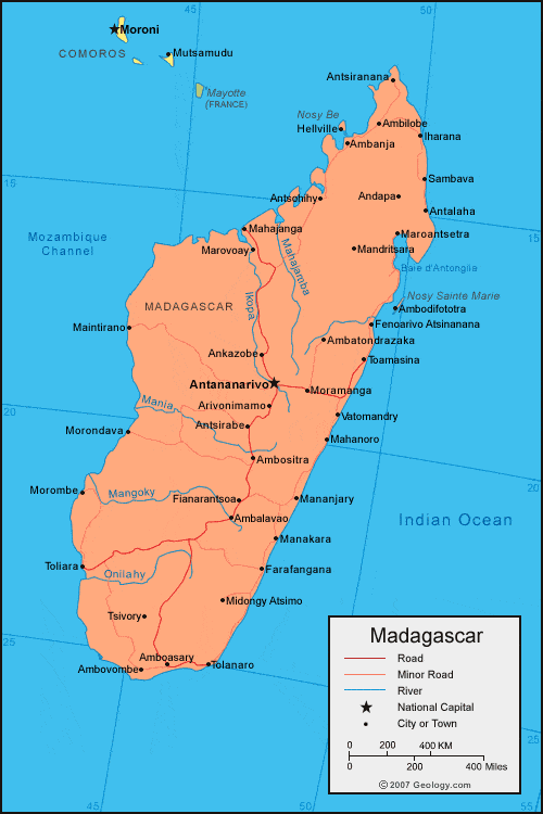
Madagascar is an island country lying off the southeastern coast of Africa. Madagascar is the fourth largest island in the world, after Greenland, New Guinea, and Borneo.
Although located some 250 miles (400 km) from the African continent, Madagascar’s population is primarily related not to African peoples but rather to those of Indonesia, more than 3,000 miles (4,800 km) to the east. The Malagasy peoples, moreover, do not consider themselves to be Africans, but, because of the continuing bond with France that resulted from former colonial rule, the island developed political, economic, and cultural links with the French-speaking countries of western Africa. The animal life and vegetation of the island are equally anomalous, differing greatly from that of nearby Africa and being in many respects unique. Although the coastlands have been known to Europeans for more than 400 years and to Arabs for much longer, recent historical development has been more intense and concentrated in the central plateau, which contains the capital city of Antananarivo (formerly Tananarive).
Land
Madagascar is located in the southwestern Indian Ocean and is separated from the African coast by the 250-mile- (400-km-) wide Mozambique Channel.
Relief
Madagascar consists of three parallel longitudinal zones—the central plateau, the coastal strip in the east, and the zone of low plateaus and plains in the west.
Situated between 2,500 and 4,500 feet (800 and 1,400 metres) above sea level, the plateau has been uplifted and worn down several times and is tilted to the west. Three massifs are more than 8,500 feet (2,600 metres) high. The Tsaratanana region in the north is separated from the rest of the plateau by the Tsaratanana Massif, whose summit, Maromokotro, reaches 9,436 feet (2,876 metres) and is the highest point on the island. Ankaratra Massif in the centre is an enormous volcanic mass whose summit, Tsiafajavona, is 8,671 feet (2,643 metres) high. Ankaratra is a major watershed divide separating three main river basins. Farther south, Andringitra is a vast granite massif north of Tôlan̈aro (Faradofay); it rises to 8,720 feet (2,658 metres) at Boby Peak.
The plateau slopes with some regularity toward the extreme southern plain, but its boundaries to the east and west are more abrupt. To the east it descends in a sharp fault, by vertical steps of 1,000 to 2,000 feet (300 to 600 metres). This cliff, which is called the Great Cliff or the Cliff of Angavo, is often impassable and is itself bordered by the Betsimisaraka Escarpment, a second and lower cliff to the east, which overhangs the coastal plain. Behind the scarp face are the remains of ancient lakes, including one called Alaotra. To the south the two steep gradients meet and form the Mahafaly and the Androy plateaus, which overhang the sea in precipitous cliffs. Toward the west the descent is made in a series of steps. However, in places the central plateau is bordered by an impassable escarpment, such as the Cliff of Bongolava in the west-central part of the island. To the extreme north the plateau is bordered by the low belt of the Ambohitra Mountains, which include a series of volcanic craters.
The coastal strip has an average width of about 30 miles (50 km). It is a narrow alluvial plain that terminates in a low coastline bordered with lagoons linked together by the Pangalanes (Ampangalana) Canal, which is more than 370 miles (600 km) long. To the south of Farafangana the coast becomes rocky, and in the southeast there occur many little bays. To the northeast is the deep Bay of Antongil (Antongila).
The western zone is between 60 and 125 miles (100 and 200 km) wide. Its sedimentary layers slope toward the Mozambique Channel and produce a succession of hills. The inland (eastern) side of these steep hills dominates the hollows formed in the soft sediments of the interior, while the other side descends to the sea in rocky slopes. The coastline is straight, bordered by small dunes and fringed with mangroves. The currents in the Mozambique Channel have favoured the offshore deposit of alluvium and the growth of river deltas. On the northwestern coast there are a number of estuaries and bays. This coast is bordered by coral reefs and volcanic islands, such as Nosy Be (Nossi-Bé), which protects Ampasindava Bay.
Drainage
The steep eastern face of the plateau is drained by numerous short, torrential rivers, such as the Mandrare, the Mananara, the Faraony, the Ivondro, and the Maningory, which discharge either into the coastal lagoons or directly into the sea over waterfalls and rapids. The more gently sloping western side of the plateau is crossed by longer and larger rivers, including the Onilahy, the Mangoky, the Tsiribihina, and the Betsiboka, which bring huge deposits of fertile alluvium down into the vast plains and many-channeled estuaries; the river mouths, while not completely blocked by this sediment, are studded with numerous sandbanks.
There are many lakes of volcanic origin on the island, such as Lake Itasy. Alaotra is the last surviving lake of the eastern slope. Lake Tsimanampetsotsa, near the coast south of Toliara (formerly Tuléar), is a large body of saline water that has no outlet.
Soils
The central plateau and the eastern coast are mainly composed of gneiss, granite, quartz, and other crystalline rock formations. The gneiss decomposes into red murrum, laterite, and deeper and more fertile red earths, giving Madagascar its colloquial name the Great Red Island. Fertile alluvial soils in the valleys support intensive cultivation. There also are scattered volcanic intrusions that produce fertile but easily erodible soils. Lake Alaotra is a large sedimentary pocket in the central plateau containing some of the island’s most productive farmland. The western third of the island consists entirely of deposits of sedimentary rock, giving rise to soils of medium to low fertility.
Climate of Madagascar
The hot, wet season extends from November to April and the cooler, drier season from May to October. The climate is governed by the combined effects of the moisture-bearing southeast trade and northwest monsoon winds as they blow across the central plateau. The trade winds, which blow throughout the year, are strongest from May to October. The east coast is to the windward and has a high annual rate of precipitation, reaching nearly 150 inches (3,800 mm) at Maroantsetra on the Bay of Antongil. As the winds cross the plateau, they lose much of their humidity, causing only drizzle and mists on the plateau itself and leaving the west in a dry rain shadow. The southwest in particular is almost desert, with the dryness aggravated by a cold offshore current.
The monsoon, bringing rain to the northwest coast of Madagascar and the plateau, is most noticeable during the hot, humid season. The wind blows obliquely onto the west coast, which receives a moderate amount of precipitation annually; the southwest, which is protected, remains arid. Annual precipitation drops from about 80 inches (about 2,000 mm) on the northwestern island of Nosy Be to about 40 inches (1,000 mm) at Maintirano on the west coast to about 14 inches (360 mm) at Toliara in the southwest. The plateau receives moderate levels of precipitation, with about 50 inches (1,200 mm) falling annually at both Antananarivo and Fianarantsoa, which lies about 200 miles (320 km) farther south.
July is the coolest month, with mean monthly temperatures around the island ranging from the low 50s F (low 10s C) to the high 70s F (mid-20s C), and December is the hottest month, with temperatures between the low 60s and mid-80s F (mid 10s and high 20s C). Temperatures generally decrease with elevation, being highest on the northwest coast and lowest on the plateau.
Tropical cyclones are an important climatic feature. They form far out over the Indian Ocean, especially from December to March, and approach the eastern coast, bringing torrential rains and destructive floods.
Plant and animal life
Much of the island was once covered with evergreen and deciduous forest, but little now remains except on the eastern escarpment and in scattered pockets in the west. The plateau is particularly denuded and suffers seriously from erosion. The forest has been cut in order to clear rice fields, to obtain fuel and building materials, and to export valuable timber such as ebony, rosewood, and sandalwood. About seven-eighths of the island is covered with prairie grasses and bamboo or small thin trees. There also are screw pines, palms, and reeds on the coasts. In the arid south of the island grow thorn trees, giant cacti, dwarf baobab trees, pachypodium succulents, and other xerophytes (drought-resistant plants) that are peculiar to the island.
Because of the island’s isolation, many zoologically primitive primates have survived and evolved into unique forms. About 40 species of lemurs are indigenous to Madagascar. Several unique hedgehoglike insectivores, such as the tenrec, have evolved there, and there are also many kinds of chameleons of varying size. Birds are numerous and include guinea fowl, partridges, pigeons, herons, ibis, flamingos, egrets, cuckoos, Asian robins, and several kinds of birds of prey. There are about 800 species of butterflies, many moths, and a variety of spiders. The only large or dangerous animals are the crocodiles, which occupy the rivers. The snakes, including the do, which is 10 to 13 feet (3 to 4 metres) in length, are harmless.
Inland waters contain tilapia (an edible perchlike fish), rainbow trout, and black bass. Marine fish and crustaceans abound on the coasts and in the lagoons, estuaries, and even in some upland streams. They include groupers, giltheads, tuna, sharks, sardines, whitings, crayfish, crabs, shrimps, mussels, and oysters. The coelacanth, referred to as a living fossil and once thought extinct for millions of years, inhabits offshore waters.
Additional Information
Located off the east coast of Africa in the Southwest Indian Ocean, Madagascar is the world’s fourth largest island; at 146 million acres, it’s almost the size of Texas. Madagascar’s climate is tropical along the coast, temperate inland, and arid in the south. The island harbors lush rain forests, tropical dry forests, plateaus, and deserts. Its more than 3,000 miles of coastline and over 250 islands are home to some of the world’s largest coral reef systems, tidal marshes, seagrass beds, and most extensive mangrove areas in the Western Indian Ocean.
More than 11,000 endemic plant species, including seven species of baobab tree and all lemur species, share Madagascar with a vast variety of mammals, reptiles, fish, amphibians, and birds. Along the Northern Mozambique Channel, in the northwest, is Nosy Hara National Park, a world hotspot of marine diversity where an incredible 265 species of corals can be found. The country’s interior has several critically threatened species including the smallest chameleon in the world, Brookesia micra, and Verreaux’s sifaka, a lemur found in the southwest forests.
People and communities of Madagascar
Madagascar has a population of more than 21 million people with a wide array of faiths and customs, more than 20 ethnic groups coexist on the island. A majority of the population—70 percent of which is estimated to live below the international poverty line—depends completely on natural resources via subsistence farming and fishing. The ocean surrounding Madagascar has long been an important resource for coastal populations. 1.5 million people depend on fishing for their livelihoods and marine ecotourism is a growing sector of the national economy. Well over half of fishers are women and women are the primary cleaners, processors, and sellers of marine products.
Climate change
Climate change is causing increased and more severe drought in the south and more intense cyclones and flooding in the middle and north regions of Madagascar. This extreme weather forces millions of people to migrate across the country and puts added pressure on resources, including forests and fisheries. Warming oceans due to climate change is also leading to mass mortality in coral reefs.
Deforestation
The small-scale but widespread clearance of inland forest and coastal mangroves, primarily for firewood and charcoal production, is jeopardizing the island’s habitats and species such as lemurs and chameleons. Deforestation increases sediment flow out to the ocean and can smother coral reefs and reduce the productivity of fisheries.
Climate change has also increased the severity of droughts. Droughts are causing a surge in migration towards the country’s coastal areas and people are transitioning from agriculture to fishing, putting additional pressure on coastal environments and increasing demand for mangrove charcoal and timber. Over 12,000 acres of mangroves have been lost since 1996.
Governance and security
Only 3.1% of marine areas are formally protected in Madagascar and limited staff capacity and resources to manage and create marine protected areas hinder effective legislation. Management issues can impact distribution of industrial fisheries licenses and fish trader permits while inadequate monitoring, control, surveillance, and enforcement can exacerbate overfishing and illegal fishing.
The complicated history of Madagascar and its legal system contributes to significant policy variations across the country, complicating integration across economic sectors and with the broader Southwest Africa region to address cross-cutting policy and governance issues.
Unsustainable Fishing
It is estimated that some 130,000 tons of fish are illegally fished from Madagascar’s marine territories every year, amounting to a loss of $142.8 million in potential income. Bottom trawling and seine netting degrade and damage coral reefs, threatening the long-term resource availability and food security for coastal communities. As reefs degrade, fishers are forced to find different, less exploited reefs and may repeat the same damaging practices. Under weak governance and rising insecurity, unsustainable fishing practices thrive and threaten coastal livelihoods and food security. Illegal, unreported, and unregulated fishing is a pervasive problem and contributes to overfishing.
It appears to me that if one wants to make progress in mathematics, one should study the masters and not the pupils. - Niels Henrik Abel.
Nothing is better than reading and gaining more and more knowledge - Stephen William Hawking.
Offline
Pages: 1